
 |
 hen the Soviet Union's sealed south-east border with China briefly opened recently, so too did an opportunity to travel a long-severed section of the ancient Silk Roads. We seized it, skirting the northern rim of the Tian Shan, a majestic mountain range 6,000 meters high (19,500 feet) and 3,000 kilometers long (1,850 miles), from Soviet Central Asia to Chinese Turkestan.
The Chinese called it "Tian Shan Pei Lu" - The Road North of the Heavenly Mountains. It was a popular alternative to crossing those mountains, or the equally lofty Pamir, Karakoram and Kunlun ranges further south, where altitude sickness afflicted both men and pack animals, and trails were so treacherous that merchants often had to carry some of their goods themselves to lighten their animals' loads.
But the northerly route was only passable when the steppes which it crossed were not in contention. And as territorial strife and warfare often did afflict the area, the merchants, for the most part, were forced to cross the mountains that made up "the roof of the world."
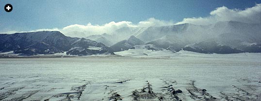 |
| A frozen mountain lake in the Tian Shan, northwest China. |
Although easy going compared to this alternative, the Road North was for us the most difficult part of our journey, for even without the threat of war, this route crossed some of the most isolated country in the world - a sobering reminder of the dangers of the ancient Silk Roads.
From Samarkand, our train headed north to Tashkent. According to al-Biruni, an 11th-century Arab scholar and scientist, this city was none other than the so-called Stone Tower, where the Roman geographer Ptolemy said Western and Chinese merchants met regularly in the first century to exchange goods.
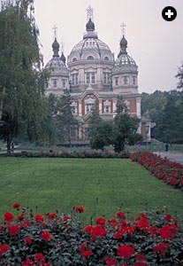 |
| Alma Ata cathedral |
But at least three other locations in Soviet Central Asia and Afghanistan have been identified as the Stone Tower. And since Tashkent was rebuilt as a showpiece of modern Soviet architecture, after a 1966 earthquake leveled a third of the city, there is little left to prove al-Biruni's claim: Monolithic buildings squat in vast squares, and where caravan trails once crossed there is today an enormous divided-highway intersection dominated by a 23-story hotel.
It is not disputed, however, that it was through the Ferghana Valley, not far from Tashkent, that the Chinese made their first westward thrust through the Heavenly Mountains, late in the second century BC.
The man principally responsible for opening up this route through the Tian Shan was Zhang Qien, who, in 138 BC, was sent by the Han emperor Wu to seek alliances among the peoples of Central Asia against China's chief enemy, the Huns. Although he failed in his mission - he was twice captured by the Huns, failed to forge any alliances and returned after 13 years with only one of his original 100 men - the wanderings of the indefatigable Zhang Qien laid the groundwork for the Silk Roads from China to the West.
Emperor Wu was particularly impressed by the stories Zhang Qien brought back of a race of "celestial horses" raised on the rich pasturelands of Ferghana: Big, strong and intelligent, they seemed to be the perfect answer to the slashing cavalry tactics of the Huns.
It was to obtain some of these heavenly horses that Emperor Wu sent an army of tens of thousands of soldiers 4,000 kilometers (2,500 miles) across the Taklamakan Desert and the Tian Shan to Ferghana, opening up Central Asia to Chinese power for the first time.
In 121 BC the Chinese drove the Huns north, and in 106 BC the first through caravan from China reached Parthia.
The Parthian and Sassanian Persians controlled East-West trade for 800 years - until, starting in 705, the great Arab general Qutaiba ibn Muslim marched east into Central Asia and, in a series of brilliant campaigns over the next 10 years, conquered Bukhara and Samarkand and finally reached Ferghana, from where he crossed the Tian Shan to Kashgar.
 |
Direct conflict between the Arabs and the Chinese was avoided on this occasion, legend says, when the Chinese provincial governor, hearing that Qutaiba had sworn to take possession of China's land, wealth and people, sent him a bag of Chinese soil, a pile of Chinese coins and four Chinese princes as prisoners, thus giving the Arab general a symbolic victory he was willing to accept.
It was not until 751, by which time Islam had absorbed the Sassanian and large sections of the Byzantine Empire, that Arab and Chinese armies met face to face, at the Battle of Talas, northeast of Tashkent (See Aramco World, September-October 1982).
Although the Muslims were victorious there, they advanced no farther east. Farther penetration of the Islamic religion had to wait until the 10th century, when the ruler of Kashgar became a Muslim. This event marked the death knell of Buddhism - until then the prevalent religion - in the region. The people of western China have remained Muslim to the present day. And although communism now rules there politically, Islam is still a dominant moral force in the region, freely practiced after severe repression during China's Cultural Revolution.
Arab merchants, however, did make immediate inroads after the Battle of Talas: They established direct contact with China by land and sea. By the ninth century, Baghdad was one of the main market places of the world and the Arabs were the new middlemen between West and East. China developed a taste for exotica from the Islamic world that profoundly affected Chinese style in future centuries. The Turkish shadow plays known as karagöz, musicians and musical instruments from Bukhara and Samarkand, and dancers from Tashkent were all welcome at the Tang court.
 |
The "heavenly horses" continued in vogue. During the Tang Dynasty, artists and sculptors immortalized them. The most splendid example is the world-famous "Flying Horse," one hoof poised on a swallow's back, excavated by Chinese archeologists along the Silk Road near Xian in 1969.
Although this breed is long extinct, the rearing and rifling of fine horses is still an important feature of the Kazak steppe - a vast pastureland where the Soviet Union now launches and lands its space vehicles, stretching from the Volga River in the west to the Heavenly Mountains in the east.
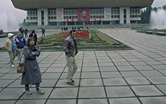
Where the steppe and mountains meet stands Alma Ata, capital of Kazakstan, the USSR's second-largest republic. It is surely one of the most beautiful cities in the country: Apple orchards - Alma Ata means "father of apples" in Kazak Turkish - cover the slopes of the foothills and merge with the city's spacious parks and public gardens against a backdrop of snow-capped mountains.
That night, our last in the Soviet Union, there was a merry gala dinner with entertainment, dancing and speeches. Even the normally glum Intourist official from Moscow, who had been responsible for our party throughout its travels across the country, managed a smile - probably at the thought of our imminent departure.
 |
 |
| Panfilov's multi-cultural mosque. |
Early the next morning, with police cars front and rear and guards posted at key points en route, we set off in a convoy of seven red-and-white buses across the forbidden Sino-Soviet border zone.
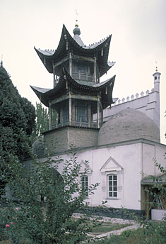
The mosque at Panfilov, the last town on the Soviet side of the frontier, spoke volumes: The facade was typical of the austere Islamic architecture of Central Asia, while the minaret was shaped like an ornate Chinese pagoda.
Politics, however, does not mix as easily as cultures do, and the differences between Moscow and Beijing run deep in the Ili Valley - a natural corridor for trade and conquest between the two countries. In 1870 the Russians occupied the Ili region of China, and although they withdrew a decade later the area has remained a bone of contention - a sensitive region almost permanently closed to foreigners, and the site of occasional flare-ups of armed conflict.
Three years ago, however, the British travel firm Voyages Jules Verne, which specializes in off-beat holidays, persuaded the Soviet and Chinese authorities to reopen their border - closed since the 1960's - long enough to allow a "commemorative" journey along the Silk Roads. Since then, the border has reopened at least once a year to permit similar pilgrimages.
Passing through this usually closed door at Hurgos, we went from one world to another. The Soviet side was a walled outpost, deserted except for troops and border officials, efficient but aloof. The Chinese side, in contrast, was chaotic and friendly. It opened up directly into town, where soldiers played drums and cymbals, lion dancers pranced in the streets and hundreds of people turned out to greet us. En route by bus to our hotel in Yining, a town normally off-limits to foreigners, our "guide" made up for his total lack of English by serenading us in Chinese.
We were now in the Xinjiang Uygur Autonomous Region, formerly Chinese Turkestan. A vast, 1,650,000-square-kilometer (637,000-square-mile) area of steppe, desert and mountain, it covers one-sixth of China's total land area and is its largest administrative unit. Here, the people are mainly Turkic and Muslim, and despite Chinese efforts to resettle the region it retains a distinct Central Asian atmosphere of its own.
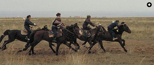
Next day, hurried along by icy winds and snow flurries, we were bused to a remote plain to witness one of the last vestiges of the ancient nomadic empires of the steppe, the annual Kazak rodeo.
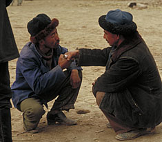
There, silhouetted against the darkening sky for all the world like Ghengis Khan's cavalry, were some 1,000 men, women and children, hunched on horseback or huddled in carts, awaiting the main attraction of the day - us: Foreigners are rare in the closed border areas of China. There could not have been a sharper contrast: we with our soft skins and heated minibuses and they with their creased leather faces and sturdy steppe ponies.
Our mutual curiosity satisfied, the Kazaks, an ethnic group descended from Turkic and Mongol tribes, got down to the skilled riding that they do best. First, 50 youngsters galloped round and round a flag-marked course in a grueling mini-marathon; then women pursued men on horseback and beat them with their riding whips in what we were told was an ancient, and no doubt endearing, form of Kazak courtship; and finally there was a game of ulak tartish , an unruly battle-game played - or fought - over a goat's carcass. As we left, army officers there to supervise the game were wading into the melee themselves.
That night, back at the hotel, there was a banquet - a mixture of Chinese and Turkic dishes - with dancing, singing and speeches about friendship and cooperation. The mayor even got in a plug for local investment opportunities.
 |
| Western tourists and Kazak horsemen represent contrasting lifestyles. |
China's rail network does not reach to this remote corner of the country, so we set off in the dark of the next morning in a convoy of 12 minibuses, with a military escort, along the Tian Shan Highway. But although the road crosses the Heavenly Mountains at their relatively low-lying eastern extremity, we were soon in trouble. Picture-postcard scenes of towering Tian Shan pines in steep-sided valleys were obliterated by driving snow. The buses, lacking snow chains, began slithering all over the road. Finally we came to a dead stop on an icy incline littered with stranded trucks.
 |
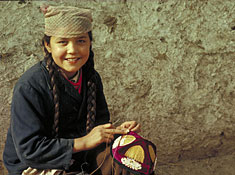 |
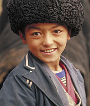
| An Uygur girl embroiders a traditional cap. |
Advance seemed impossible, retreat unthinkable. But we had reckoned without that unique Chinese substitute for machines - the people power that has been crucial to the development of modern China. The officials, soldiers and guides accompanying us simply manhandled the buses up the mountain without most of the passengers even having to get off.
Once over the mountains the snow stopped and we picnicked by a frozen lake; it was too cold to stay still but the views were spectacular. For the rest of the day we drove across endless, seemingly unpopulated plateaus, the peaks of the Heavenly Mountains ever-present to our right. Fourteen bone-shaking hours later, with our driver too tired to see - let alone avoid potholes - and our guide singing lustily to keep him awake, we arrived in Shihezi. It was so cold that night in our unheated hotel that Aramco World photographer Tor Eigeland wore his Russian fur hat to bed.
The worst, however, was over. The next day dawned bright and sunny and it was but a brief further bus ride to China's new northwest railhead and - to our vast relief - a "soft class" train, the Chinese equivalent of first class.
Ours was the first passenger train to travel on the recently extended track from Shihezi to Ürümqi, and we were given a rousing send-off: Banners in English and Chinese fluttered over the newly-built platform, and children with classically made-up faces sang to us.
A few hours later, we too said goodbye to the rest of the group and disembarked in Ürümqi, capital of the Xinjiang Uygur Autonomous Region and a city farther from the sea than any other in the world. Here, the semi-tribal, still nomadic Kazaks of the Tian Shan and steppe rub shoulders with Han Chinese transplanted from the East and with the city-dwelling Uygur Turks, from whom the region takes its name.
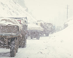 |
| Stranded trucks block passage through the Heavenly Mountains. |
The Uygurs once ruled Mongolia, built its first walled cities and created its first literate civilization. But in 840 another Turkic people, the Kirgiz, drove them southwest to Xinjiang, where they established the kingdom of Kocho and inhabited the oasis towns through which passed the ancient Silk Roads. Later, when no central power controlled them, these oases became petty independent states.
Most of these walled oasis towns, which once gave respite to generations of travelers, are now closed to foreigners. But Kashgar, in far western China, is accessible, though only just: It is surrounded on three sides by some of the highest mountains in the world, and the fourth side is blocked by desert.
Here, caravans rested between two of the most hazardous obstacles of the Silk Roads: the icy heights of the "roof of the world" and the arid wastes of the Taklamakan Desert, whose name in Turkic means "who enters, never returns."
Here too, where the British, Russian and Chinese Empires met, was played out the Great Game, the extraordinary, centuries-long espionage war between Britain and Russia for control of Central Asia, fictionalized in Rudyard Kipling's Kim .
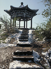 |
| The Red Hill Pavilion. |
Even today, only the most determined travelers reach Kashgar, either by way of the newly-built Karakoram Highway from Pakistan, or, like us, via Ürümqi. Our unromantic reward was to find that, despite its isolation and its exotic history, Kashgar too is slowly being turned into a modern town, where the former British and Russian consulates, once hotbeds of espionage, now serve merely as down-at-heel hotels.
Once a week, however, some of Kashgar's old magic returns when thousands of people trek in on foot or in creaking donkey carts from miles around to buy, sell or simply browse at the city's Sunday market, one of the oldest and largest in Central Asia. Arriving in a steady stream from dawn onward, they spread out their wares on the edge of town: magnificent fox furs and cast-off clothing, colorful Kirgiz carpets and battered bicycles, ornate daggers and sacks of grain.
By noon, there is hardly room to move. Men in black corduroy frock coats, knee-high leather boots and fur-trimmed hats haggle over merchandise, or take turns in a nearby clearing test-riding horses at breakneck speeds.
And half a dozen two-humped Bactrian camels, patiently awaiting buyers, recall more glorious days when it was their steady, mile-eating gait that provided the main link between China and the West.
 |
| Heavenly Mountain lower slopes covered with towering Tian Shan pines. |
< Previous Story | Next Story >


