 |
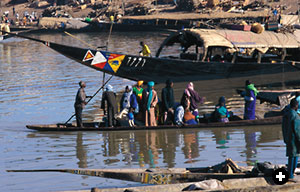
| His passengers carefully balancing, a boatman poles his pirogue up to the Niger’s embankment at Mopti. Behind the pirogue, a long-distance cargo and passenger pinasse is docked. |
 |
 ll were writing of the vast and unknown Niger River, on whose banks some of Africa’s greatest empires rose and fell.
Other writers, thinking it was a tributary of the Nile, named it “Nil al-Sudan” (“the Nile of the Blacks”); still others claimed it was the headwaters of either the Senegal River or the Gambia —or both. Mungo Park, the Scotsman who paid with his life to be the first westerner to reach it, compared it to the Thames at Westminster. When Park explained to the King of Segou that he had come from a great distance through many dangers to behold it, “He naturally inquired,” Park wrote, “if there were no rivers in my own country and whether one river was not like another.”
To Europeans, in fact, the Niger River was not like any other. Its mystery was part of the broad fascination with Africa, particularly in late–18th-century London, where it was the subject of betting pools and exploration societies. Henry Barth, one European explorer, called it “the great river of Western Africa, whose name under whatever form it may appear—whether Dhiuliba, Mayo, Eghirreu, Isam, Kwara, or Baki-n-ruwa—means nothing but ‘The River.’”
On July 20, 1796, when Park became the first European (after Leo Africanus) to lay eyes on it, he wrote, “I saw with infinite pleasure the great object of my mission, glittering in the morning sun, flowing slowly to the east…the long sought for, majestic Niger.”
With the question of the direction of its flow answered, Park died 10 years later seeking the river’s mouth. “Even those merchants arriving from the eastward are ignorant of the termination of the river,” he wrote in exasperation. “For such of them that can speak Arabic describe the amazing length of its course in very general terms, saying only that they believe it runs to the world’s end.”
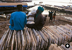 |
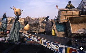
| Salt merchants Hasny Ould Fally and Sidi Ahmad Fally came downriver to sell salt mined from the Taodenni salt flats north of their home in Timbuktu. |
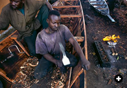 |
| A boatwright on Mopti’s waterfront shapes the casedral woodwork of a new pinasse with an adze. |
 oday, questions posed by people who make their living on the Niger are far more the stuff of daily life. Have the sandbars shifted between Konna and Lake Debos? How many days’ travel from Segou to Koulikoro? What are they paying for smoked carp in Mopti? For Taodenni salt in Kabara? For Hausa cloth in Bamako?
The Niger rises 250 kilometers (155 mi) inland from the Atlantic on Guinea’s Fouta Djallon plateau. From there it begins its journey of 10 times that distance by flowing east. Along its course, the ecological zones it passes through shift from rain forest to high bush to savanna to desert and then back again. In Mali, it flows northeast, then bends southeast at the “Boucle de Niger,” then almost due south, on its way passing through an inland delta larger than several of the nearby countries and giving its name to two others —Niger and Nigeria—before disemboguing in the Gulf of Guinea near Port Harcourt, Nigeria.
Its rainy season high-water mark can be 11 meters (35') above its low, a range rivaled only by the Amazon. In flood, the Niger spreads laterally for more than 160 kilometers (100 mi) in Mali’s Lake Debos before squeezing through a rock-hewn defile at Tosaye that is barely 100 meters (325') wide. It is home to hippos, but has been known to run dry. Travel writer Ted Morgan saw it as “a moving path into the heart of the continent, a long, liquid magic wand.”
Morgan cites a theory that the Niger was once two rivers. The upper reach took a straight course northeast past Timbuktu and evaporated in northern Mali’s Djouf depression. The lower course originated in the mountainous Adrar of the Iforhas and ran south to its present mouth in Nigeria. At some point lost in time, an earthquake tied the two streams together.
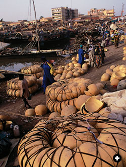 |
| Bundles of bowls cut from near-spherical calabash gourds await buyers at Mopti’s waterfront market. |
The present-day Niger has been fully mapped for only 150 years. Samuel Sidibe, director of the National Museum of Mali, says today’s knowledge is “built on the errors of the ancients. All this talk from Pliny about the source of the Niger and its crawling and squeaking and snake-eating men only confused those who came later,” he says.
The Middle Niger, or the Niger Bend, extends from the inland delta to the Mali–Niger border. This is the Niger’s historical heartland. It is to West Africa, says historian John Hunwick of Northwestern University, what the Nile Valley is to Egypt: “an ecological treasure and a civilizational magnet.”
Anchoring the Middle Niger at either end are the towns of Mopti and Gao. Mopti is the inland delta’s chief port of trade, situated on an island in the floodplain at the confluence of the Niger and its tributary, the Bani. It is connected to the Niger’s south bank by a French-built causeway. The town of Gao could hardly be more different.
Once the seat of the Songhai Dynasty, the greatest of the native West African empires, Gao today is a nearly forgotten footnote, a quiet backwater steeped in pre-colonial grandeur. Between them, the towns sew together the Bend and embody the river’s shifting fortunes.
 aba Tomata is a 30-year-old fisherman turned boatman, captain of a 20-ton vessel known here as a pinasse that he runs out of the teeming Mopti waterfront. He plies unfixed routes on the inland delta past his home in Jafrabe village. His pinasse—the narrow-beamed, high-sterned, redwood-hulled workhorse of the river’s cargo trade—flies his personal ensign, which is a variation of the Malian national flag’s colors of green, yellow and red. A checkered logo identifies its maker as Ali Ire, a noted pinasse builder. “It’s only a year old and has a rebuilt Mercedes diesel. It cost $3000, and I treat it with care.” Every three trips up and back from the delta, Tomata changes his engine oil and rubs the old oil into the hull as a preservative.
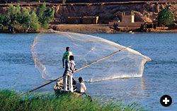
The eve of Wednesday’s grand market is a whirlpool of waterborne traffic moving to and fro. Nosing in for landings at the cobblestone embankment, built by the French in the 1930’s, come chugging pinasses laden to the gunwales with rice and fish and millet. Pushing off on quick glides across the river’s inner harbor go two- and three-passenger pirogues, paddled or poled Venetian-style.
 |
| Fishermen near Gao are most likely to catch carp, catfish and Nile perch among the approximately 150 species of fish known to inhabit the Niger. |
A flat-bottomed steamer operated by the Compagnie Malienne de Navigation tilts unsteadily on the mudflats, awaiting the summer’s rains to clear the Niger’s unpredictable shallows and make the 10-day run from Mopti to Gao navigable again. As if to mock its stranded hulk, a spinnaker-rigged pirogue fishtails lightly downwind against the current.
Up the embankment, market stalls spill out and topple over with sacks of cured fish and piles of firewood, carved calabash ladles and aluminum cooking pots, bags of dried okra and pearl millet, strings of goat cheese and balls of creamy shea butter. Mopti’s market language is Bambara, the lingua franca for most Malians, but snatches of Bozo, Songhai, Dogon and French are interjected as necessary—except under an awning on the salt-sellers’ quay, where the language is Arabic.
Thirty-year-old Hasny Ould Fally and his younger brother Sidi Ahmad are Malian Arab salt merchants from Timbuktu. They came to market a few days earlier with a pinasse loaded with tablets of salt they had bought in Kabara, Timbuktu’s port, from a camel caravan arriving from the Taodenni salt flats some 640 kilometers (400 mi) to the north.
“Sometimes I organize a camel caravan, but I prefer not to,” explains Hasny. “Two men and 40 camels, each carrying four 50-kilogram (110-lb) tablets for 15 days, just to triple my money—it’s not worth it. I can double my money by buying in Kabara and hiring a pinasse. Believe me, three days on the water is a lot easier than two weeks in the desert.”
The salt sellers operate a small factory under their tent, sawing each of the rectangular tablets into 15 retail-sized “plaquettes.” Loose salt from the sawing sells for upward of 25 us cents per kilo, depending on the quality. (There are four categories, from dirtied crystals to pure white.)
When Hasny is lucky, his entire stock is bought by an importer from Burkina Faso. “Burkinans like Taodenni salt, but don’t ask me why,” he says.
In Mopti’s boatyards, men are busy seven days a week. Pirogue-builder Kono Karabenta operates right in the middle of the embankment. His distinctive black and white logo, looking something like a Parcheesi board, adorns the hulls of many small craft. An outdoor sign is large enough to be read from the middle of the channel. “Kono Karabenta. Seller. Pirogues and Wood.”
“I employ 40 men here, from nail makers to hull stringers,” says the youthful Kono. “I give easy credit to my customers and good work to my boatwrights.” An entire production line sits under one roof. Blacksmiths, attended by boys turning bicycle-wheel–powered bellows, make square-headed nails from flattened tin cans. Sawyers rough out long and narrow planks of casedral, a tropical hardwood. Framers set up ribs and gunwales.
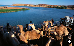 |
| Long a desert crossroads, Gao is visited today by Tuareg traders who come to its camel market. They reach it by ferry from the Niger’s south bank. |
A 14-meter (45'), seven-thwart pirogue is just now in its last stage. The hull is being charred inside and out and then adze-finished to thin and even its symmetry. Nails are set in triple rows. Knots in the wood are knocked out and their holes filled with custom-shaped casedral plugs that are then sealed with baobab leaves and tar.
Only the final step is lacking to sew up the job, so to speak: Most pirogue hulls are built in separate fore and aft halves. These are then stitched together with water-resistant cordage made from baobab bark. This allows an owner to lengthen the boat at a later time by opening the suture and adding a midsection, much like an extra leaf in a dining-room table. It’s a technique that dates from when pirogues were made from dug-out tree trunks, for Mungo Park observed the boats “formed of the trunks of two large trees, rendered concave and joined together not side by side but endways.”
In a mounting flurry as dusk nears, arriving pinasses push their way into the crowded dock space. Most come in overloaded, drawing too much water to make a clean landing; they begin unloading—sack by sack, one stevedore at a time wading back and forth—a few meters offshore. As the boat rides higher, it slips in, until when it’s finally close enough, three gangplanks are laid from gunwale to dry land, and the passengers stream off.
The boatmen aren’t the only ones watching the water. Fisheries expert Mamadou Adama Diarra is worried. “There is too little water in the Niger, even though last rainy season was generous. The fish are suffering.” Mopti’s annual fish catch—mostly catfish, Nile perch and carp among 150 other varieties—has dropped from 100,000 to 80,000 tons, due, he says, to insufficient flooding during the spawn. Even in good years, Diarra explains, 65 percent of the flow at Mopti evaporates in the inland delta beyond. In the worst of the 1980’s drought years, the river reportedly stopped flowing altogether downstream of Niamey, the capital of Niger.
Not just fish suffer when the river falls. Hippos have long made the Niger River their home. Ibn Battuta remarked that “they have manes and tails like horses and feet like elephants…. They swim in the river and lift their heads and blow.” But lately their numbers in the inland delta have been dropping, and their only stable population is downstream of Gao.
eginning in the ninth century, when Arab merchants first established an entrepôt at Essouk, a nearby oasis in the Tilmesi Valley, Gao has been a crossroads for African travelers heading east to Makkah, north to the Mediterranean and south to Hausaland. Traders came to buy and sell Ghanaian gold, Barbary horses, Damascene silks and Saharan salt.
 |
| Today, most of the trade that made Gao a regional economic and political center lies several centuries in the past. |
According to the Andalusian geographer Abu ‘Ubayd al-Bakri, Gao was founded in the late seventh century by Sorko fishermen and was origi- nally named KawKaw or GaoGao, an onomatopoetic tribute to the beat of their tom-toms. By 872, al-Ya‘qubi wrote that Gao was “the greatest kingdom of the Blacks.”
Gao’s first Songhai dynasty was the Za, or Zuwa, who claimed a legendary tie to Yemen. King Kusoy, the 14th of the Za line’s 32 rulers, converted to Islam in 1009. Tombstones of Moroccan marble, inscribed in a fine Andalusian hand, were discovered in the town in 1939. One inscription from the year 1100 reads, “Here is the tomb of Abu Abdullah Muhammad, the king who defended God’s religion and who rests in God.” But few of these tombstones remain, most having been carried off to French museums and private collections.
Ibn Battuta, nearing the end of his travels, came to Gao in 1352. His description of the market—perhaps not surprisingly for a man who had seen most of the world’s treasures—concentrates less on luxuries than on edibles. “It is one of the finest and biggest cities of the Blacks, and best supplied with provisions…: plentiful rice, curds, chickens and fish, and melon which is incomparable.”
The market today is far less plentiful, isolated from the river, and thus from easy resupply, in these times of chronic low water. The vendors tending near-empty stalls outnumber the few buyers, who come mostly to browse. The liveliest shop belongs to an incense dealer, whose burning sample drifts in lazy curls out the door and down the street.
 |
| The historic center of Gao is the 16th-century mosque of Askia the Great, founder of the Songhai Empire’s last dynasty. Built of mud brick, it is pierced by wooden spars that serve as scaffolding for the mosque’s annual replastering. |
In 1464, Gao was wrested from the Malian Empire back to local control by Sonni Ali, founder of the second Songhai Dynasty, which brought down the Malians and, in daring naval campaigns, expanded Songhai rule westward beyond Timbuktu and Djenné. That Songhai power was based as much on its navy as its cavalry is evident from the language’s specialized military terms for “harbormaster,” “boat-master” and “war canoe”—goima-koi, hi-koi and kunta.
Sonni Ali drowned in 1492—an unsurprising fate for a man of the river except that, according to the Songhai chronicle Tarikh al-Sudan, this occurred in the Gourma, a bone-dry desert region south of the Niger Bend. In any event, he was succeeded by Muhammad Askia, founder of the Songhai Empire’s last dynasty and known in history as Askia the Great.
The Songhais relied on naval power to extend their reach as never before. One chronicle relates that at Gao alone there were ready for muster 400 war barges, 1000 fishing boats and 600 merchant canoes. Using this river transport to rapidly move its soldiers, the Songhais reached north to the Taghaza salt pans near Morocco, east to the Bilma Oasis near Chad and west to the mouth of the Gambia River.
Leo Africanus, whose visit to Gao took place in 1510, witnessed the Askia court in action. “Between the first gate of the palace and the inner part there is a place walled round where the king decides all his subjects’ disputes,” he wrote, “and although he is most diligent in this and performs all necessary things, still he has around him many counselors and other officers, secretaries, treasurers, factors, and auditors.”
Today the emperor’s palace has disappeared. Gao’s sole surviving monument is the mosque and tomb of Askia the Great. It’s a squat earthen ziggurat pierced like a pincushion by wooden spars that serve as scaffolding for its annual replastering. The tomb’s outer staircase leads to a vantage point from which to view the river’s broad sweep past the city. On the opposite bank, near a grassy swamp, rises an anomalous rose-colored dune, atop which he is said to have died in 1528 on returning from a campaign.
 |
Passengers await the ferry across the Niger at Gao.
|
The prayer area adjacent to the tomb is a low-ceilinged labyrinth of 150 thick clay pillars, and the mihrab (prayer niche) is visible only to those standing directly before it. Outside, a freshly painted sign lists the names of all the mosque’s imams, ending with the one currently serving, Moussa Aliou.
Henry Barth’s description of the mosque, when he visited it in 1854, is still true today. “Its proportions are extremely heavy,” he wrote, “rising in seven terraces which gradually decrease in diameter so that while the lowest measures fifty feet on each side, the highest does not exceed fifteen.”
The Songhai Empire fell in 1590 at the hands of the Moroccan Sa’dian ruler Ahmad al Mansur, whose Spanish general Jawdar led a 4000-man, musket-equipped army. Having reached Timbuktu and found no river boats, the soldiers ripped doors off their frames in a hasty effort to patch together war vessels.
The Tarikh al-Sudan describes the Songhai evacuation of Gao thus: “There was loud weeping and lamentation as people began with much difficulty to cross the river in tightly packed boats. Many people drowned and God alone knows how much property was lost.” Their power broken forever, the Songhai fled in disarray into Nigeria. From this downriver exile the Songhai kings did not reemerge until 1999. Then, as part of Mali’s political decentralization policy, an honorary ruler was named in Gao to preside over tribal matters. As Mali’s former envoy to the Soviet Union, he is no stranger to the rise and fall of empires.
Following the Moroccan conquest, Gao maintained its commercial stature even if its political star was in eclipse. Its reputation reached Mungo Park far upstream at Segou, even if he did mistake its name for a local term for the Niger’s left bank. “The city of Houssa is another great mart for Moorish commerce,” he wrote in his Travels. “I conversed with many merchants who had visited the city and they all agreed it is larger and more populous than Timbuctoo.”
On Park’s second voyage in 1805, he passed Gao without stopping, but he left a lasting impression with the locals: When Barth arrived 50 years later, he met a man who remembered Park. “I had the pleasure of meeting an old man,” wrote Barth, “who gave me an accurate description of this tall commanding figure and his large boat. He related the manner in which the Tuareg of the tribe IdeMusa attacked that mysterious stranger.”
Compare this with the account of Amadi Fatoumi, a guide who accompanied Park till just before he died, and who was later interviewed by a search committee sent by Park’s London backers. “Seeing so many men killed and our superiority over them, I took hold of Mungo’s hand, saying ‘Let us cease firing, for we have killed too many already.’”
Park’s death on the river, at central Nigeria’s Bussa Falls, remains a mystery. Was he killed by local warriors unhappy at his refusal to pay customary tribute? Or did he drown trying to pass through the cataract in dangerously low water? All the search party turned up was his water-stained book of survey logarithms, now in the collection of the Royal Geographical Society.
For the next 25 years, English explorers continued to seek the Niger’s mouth. Their London paymasters had told them it could be anywhere, from the Congo to Lake Chad to the Nile. Finally, on November 18, 1830, having traveled downriver from Bussa, Richard Lander emerged from the mangrove swamps into the surf of the Bight of Benin and put the Niger’s course on the map from source to mouth.
Mopti harbormaster Mamadou Doukouré waves off all this downstream geography. Malarial swamps and rocky cataracts are unknown in his town. In his mind, the explorers should have been happy with the Middle Niger, “the crossroads of Mali, a land of fish, livestock and grain.”
Mamadou peers out from his waterfront office at the Opération de Pêche. Jaunty pirogues and heavy pinasses pass right and left. Boys knee-deep in the river make a game of scrubbing unruly goats with loofahs. Grunting stevedores heft baskets of salted fingerlings and sacks of rice. Itinerant sellers of sunglasses, sunhats and cassettes work the crowd.
Tomorrow is market day. And the Niger flows ever on to the sun.
 |
Louis Werner (wernerworks@msn.com) is a free-lance writer and filmmaker living in New York. |
 |
Free-lance photographer Kevin Bubriski (bubriski@sover.net) recently published Pilgrimage: Looking at Ground Zero (2002, Powerhouse). His photographs are in numerous museum collections worldwide. |