
Written and photographed by Peter Harrigan

|
 |
The earthquake was caused by basaltic magma, welling up through cracks in the 40-kilometer thick (25 mi) crust of the Arabian Peninsula. It was quickly followed by fiery volcanic eruptions that lasted nearly two months and spewed lava and ash from a massive fissure southeast of Madinah, throw- ing up six cones of cinders. The lava flowed for 23 kilometers (15 mi) and threatened to inundate Madinah itself.
Arab writers chronicled these events, and although a few accounts survive (see “The Madinah Eruption” below), they were soon eclipsed by more catastrophic happenings: Later that year, fire destroyed the Prophet’s Mosque; in Baghdad, the Tigris flooded, and the next year, the Mongols sacked the city, bringing the Abbasid Caliphate itself to a shocking end.
 ore than five centuries later, in 1815, the Swiss explorer and orientalist Johann Ludwig Burckhardt reached Madinah and noted that the eruption had disappeared from local memory:
 |
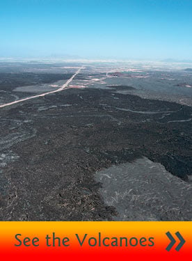
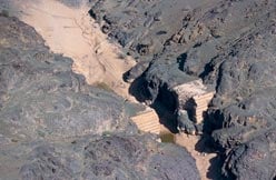
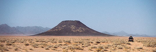
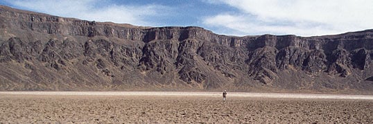
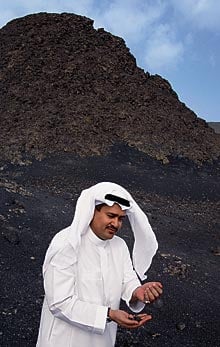
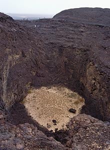
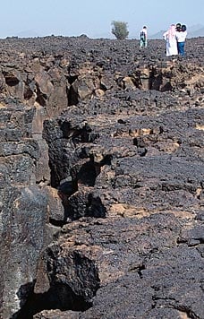
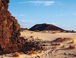
| Above: The harrah near Madinah has been active for more than two million years, explains Mohammed-Rashad Moufti, a consultant to the Saudi Geological Survey (SGS). Below: This small dam was broken by an earthquake along one of the several faults that run through the harraat. |
 |
“During my stay, I remember to have once made the observation to my cicerone, in going with him to Jebel Ohod, that the country appeared as if all burnt by fire; but I received an unmeaning reply; no hint or observation afterwards in the town which could lead me to suppose that I was near so interesting a phenomenon of nature.” It was not until his arrival in Cairo that Burckhardt discovered a written account referring to the eruption.
With the exception of Charles Doughty’s description (see “‘A Titanic Desolation’” below), European references to volcanic Arabia are few and far between. Even since the founding of Saudi Arabia in 1932, the focus on oil in the sedimentary Eastern Province and the stereotype of sand-and-gravel deserts have left largely neglected the volcanic aspects of the Arabian Shield, the geological name for much of the western Arabian Peninsula. It was not until recent years that the scientific and economic significance of this geology began to be recognized and understood.
Western Saudi Arabia is in fact covered not only with sand, but also with vast fields of lava. In Arabic, these lava fields are known as harraat. (The singular is harrah; before a name, it is harrat.) Some dozen named harraat in Saudi Arabia together form one of Earth’s largest alkali basalt regions, covering some 180,000 square kilometers (nearly 70,000 sq mi), an area greater than the state of Missouri.
 |

After the evening prayer, according to one account quoted by Johann Ludwig Burck hardt, “a fire burst out in the direction of al-Hijaz; it resembled a vast city with a turreted and battlemented fort, in which men appeared drawing the flame about, as it were, whilst it roared, burned and melted like a sea everything that came in its way. Presently a red and bluish stream, bursting from it, ran close to al-Madinah, and at the same time the city was fanned by a cooling zephyr from the same direction.”
The eruption lasted for 52 days. At its fiery zenith those further afield also witnessed strange sights, with reports of the light of the eruption visible in Makkah and Tayma’, six days’ journey from Madinah. Historians relate that the depth of the lava flow was a long spear’s length, around three meters (10'), and that it flowed like a red-blue boiling river, carrying in its way gravels, stones and trees, with thundering noises. Al-Qastalani asserts that the fire was so fierce that no one could approach within two arrow flights, and that at night “the brilliant light of the volcano made the face of the country as bright as day; and the interior of the harim (the sacred area of the city) was as if the sun shone upon it.” The governor and citizens prayed for the safety of the city, and as the lava inexorably approached, many, including women and children, wept and prayed around the Prophet’s tomb. Then, the lava current turned north, and the city was spared.
|
Mohammed-Rashad Moufti holds Saudi Arabia’s first—and so far only—doctoral degree in volcanology. He has devoted 20 years to studying and promoting awareness of the lava field near Madinah, which is known as Harrat Rahat.
“The eruption that threatened the Holy City happened very recently in geological time, and it overlaid previous lava flows. It’s known as the historic lava flow because we have recorded accounts. Volcanism first occurred on this part of the harrah two million years ago and has remained active,” explains Moufti to a group of German and Saudi visitors who stand on the fissure site. They have come as guests of the Saudi Geological Survey (SGS), which has mapped the volcanic features and pioneered geo-tours to the volcanic fields.
Moufti explains that Harrat Rahat is twice the area of Lebanon. Its pond of 2000 cubic kilometers (480 cu mi) of basalt lava stretches 310 kilometers (190 mi) from the southern outskirts of Madinah to the suburbs of Jiddah, where there are other flows that date back 10 million years. The main body of the flow measures 75 kilometers (46 mi) east to west, and lava tongues run a further 75 kilometers westward where molten basalt flowed along wadis, or valleys, broke through the 1500-meter-high (nearly 5000') mountains of the Red Sea escarpment and fanned out in dendritic tentacles across the Peninsula’s coastal plain.
Satellite and aerial photographs reveal the extent of this single harrah and the variety of volcanic features strewn across its desolate, often trackless landscape of variegated flows. Satellite images from nearly 500 kilometers’ (300 mi) altitude reveal the different colors of magma extruded in past epochs: Jet-black indicates the most recent flows, while rust-red indicates surface exposure and erosion over millions of years. White areas—with one remarkable exception—reveal by-product features known as qi‘aan (singular: qa‘)—flat expanses of silt and salt and other residue laid down after lava flows blocked watercourses to form seasonal lakes. Other sand and silt areas, deposited in craters, appear as white dots and speckles from a satellite or, from lower altitudes, as more artful shapes set within often perfectly circular crater rims. A dark crater floor lacking silt or sand may be the result of more recent, even historic, volcanic activity.
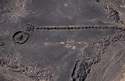 |
| A Neolithic relic that hunters may have used to guide prey across the harrah and into a corral. |
Spread across the harraat is a host of textbook geological features: scoria (cinder), spatter and tuff cones; smooth and ropy pahoehoe, sharp and broken a’a and pyroclastic flows; shield volcanoes; fumaroles; trachyte and comendite domes; eroded feeder necks; craters; fissures; vesiculated lapilli and other forms of basalt bombs; whaleback lava flows; maar craters and one stratovolcano. Some, like the maar craters—circular landforms created by explosive ash eruptions—are huge: A massive steam explosion, generated by the meeting of molten basaltic magma with subterranean water, created the spectacular maar crater of al-Wahbah on the western margins of Harrat Kashib. Some of the most distinctive volcanic scenery and geology in all of Arabia is on Harrat Khaybar, where the circular white cones of Jabal Bayda’ and Jabal Abyad look from the air like snow-capped mountains. (Both names mean “white,” one in the feminine form, the other in the masculine.)
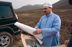
 hamer al-Khiary is a former geological engineer with the SGS who now, with the support of the agency, leads private tours into the volcanic areas. “It’s a thrill to take visitors over an apparently flat landscape and see their faces when they climb a gentle slope that breaks unexpectedly into a vast explosion crater beneath, or lead families up a scoria cone to discover at the summit a perfect rim and crater below. Our greatest thrill is to spend the night in a crater and see the inner walls sparkle with minerals in the moonlight,” says al-Khiary. At 31, wearing a polo shirt with desert-motif logo, trekking shoes and slacks and wraparound sunglasses, he looks every bit the adventure-tour guide. “What’s remarkable is that so many people have no idea that these features exist, even though they live nearby and drive past some of them on the highway.”
 |
| MAPPING SPECIALISTS |
Moufti recalls hiking into remote areas of Harrat Rahat 20 years ago with his visiting professor. “Like other geologists, he was astonished at the complexity and extent of volcanic Arabia. I remember climbing a volcanic cone, my professor wearing a battered hat and smoking a pipe. When we reached the rim and looked down to the flat crater floor, there was a Bedouin girl grazing livestock there. I don’t know who was the most surprised!”
Such idyllic scenes belie a charged, daunting and even threatened environment, for Madinah’s was not the only eruption in historic times in Arabia. In the 1970’s, the search for non-petroleum mineral resources became an impetus for surveys of harraat. The current president of the SGS, Mohammed Assad Tawfiq, was then chief geologist of the Directorate General of Mineral Resources (DGMR). Tawfiq remembered stories of the harraat from his school days in Madinah, and he deployed his team to the lava fields as part of a mapping initiative that involved hundreds of international geologists and a fleet of helicopters and other aircraft.
 |
 |
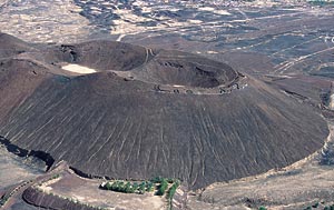
| Top: A scoria (cinder) cone in the Hayil region rises from the desert floor. Bottom: Al-Wahbah crater, nearly two kilmoeters (1.2 mi) wide, is a maar crater, formed not by volcanic eruption but by the collision of rising volcanic material with an underground body of water, resulting in a colossal release of steam—an event geologists call a phreatic explosion. |
His studies of the Madinah eruption revealed evidence of magma mixing with simultaneous extrusions of three types of basaltic lava, which demonstrated the complexity of the harrah’s subterranean “plumbing” systems. The findings, published in 1987, threw intriguing light on the relationship of tectonic forces to the harraat, for the control mechanisms at work, it turned out, are not—as most people assumed —directly related to the continental rift valleys of the Red Sea.
 |
| Above: Maher Idris, assistant president of the SGS, holds loose volcanic cinders. Along with monitoring of "geohazards"—earthquakes are riskier than volcanos, he points out—the job of the SHS is to "effectively balance exploitation with the need for geo-conservation." Below: A crater inside a large scoria cone. |
 |
The most recent eruptions on the Arabian Peninsula occurred in 1937, on a harrah near the town of Dhamar, in the north of Yemen. Before that, in 1846 an eruption took place on the volcanic Red Sea island of Saddle in the Zubair Islands, 90 kilometers (55 mi) northwest of the Yemeni port of Hodaida. Casting farther back—into the Neolithic period on the Arabian Peninsula—there is evidence of eruptions and lava flows that date to roughly 4500 BC. On Harrat Khaybar, satellite imagery has revealed at least seven post-Neolithic eruption sites and eight historic eruptions, the most spectacular from Jabal Qidr. That daunting black basaltic cone rises 322 meters (more than 1000') above a 1700-meter-high (5525') central platform; its sides sweep symmetrically up to 30-degree slopes that top out at a red-oxidized crater 400 meters (1300') in diameter. A field of ash roughly a meter (39") thick fans out more than 20 kilometers (12 mi) eastward from the crater, revealing that westerly winds predominated during the eruption. (Vague historic reports point to the likelihood that Jabal Qidr erupted as recently as about 1800, but such is the remoteness of the region, the paucity of records and the uncertainty regarding previously used local names that there is no definitive account.)

In the same area, a historic pahoehoe lava flow partially buries kite-shaped Neolithic stone fences that were probably constructed as animal traps. There is also abundant archeological evidence of Neolithic communities over the harraat of Rahat and Khaybar, where thousands of tumuli and stone fences, keyhole-shaped, kite-shaped and circular, cover extensive areas. By counting the number of vents and eruptions that have occurred on northern Harrat Rahat, volcanologists estimate that, during the past 4500 years, there have been 13 major eruptions—one every 346 years, on average.
Farther still into the past, on Harrat al-Birk, south of Jiddah on the Tihama plain near the Red Sea, lava covers gravel terraces in which archeologists have found Acheulian stone tools that date the eruption back some half-million years to Lower Paleolithic times. Much older than this, the earliest harraat of all date as early as 13 million years ago, isotopic dating suggests.
 |
 
hen it comes to English descriptions of the volcanic features of the Arabian Peninsula, none are more evocative than those of Charles Montague Doughty, whose finely observed account of his 22-month journey through central and northwestern Arabia, Travels in Arabia Deserta, was first published in 1888. Setting out in November 1876, Doughty skirted and crisscrossed the harraat of Kura, al-‘Uwayrid, Khaybar, Ithnayn and Rahat, and in doing so became one of the few Europeans to have ventured onto them.“In the train of the Harras we see a spectacle of the old volcanic violence that tormented this border of the Arabian peninsula,” wrote Doughty. “I have followed these Harras almost to Makkah; that is through nearly seven degrees of latitude.” Doughty came well-equipped, for he had studied geology at Cambridge, and he was fascinated with the emerging earth sciences of the day. In 1872 he had stood before the eruption of Vesuvius at perilously close quarters. Aptly, he places this description of the Italian eruption in the midst of his account of traversing the cinder-cone and lava wilderness of Harrat al-‘Uwayrid.
It was in Harrat al-‘Uwayrid that Doughty spent the summer of 1877 living with the Moahib Bedouin, and his account of his sojourn with them on the elemental lava fields in “high tempered air” is among the most memorable passages in the book: “This Titanic desolation, seeming in our eyes as if it could not bear life, is good Beduin ground and heritage of the bold Moahib Abu Shamah,” he wrote. “In this difficult volcanic country, their small cattle can be seldom robbed; and milk of the flocks is in less scarcity among them, which is the health and wealth of the poor nomads.”
Travel across the harraat, “more often a vast bed and banks of rusty and basaltic bluish blocks,” was a formidable task: “Because of this cumber of stones and sharp cutting lavas, the Harra country is hard to pass, out of the paths, for any other than Harra-bred camels. The heavy poised stones sliding and toppling to the tread, the herdsmen’s feet are oftentimes sorely bruised; of which, and because the stones are as glowing coals in the summer sun, the Beduin hinds in the Harra commonly sit all day upon the croups of their browsing camels.”
In addition to mapping and describing topographic and geological formations, Doughty observed Bedouin life and natural features and their relationship with the volcanic landscape. He described sulphurous warm springs issuing from basalt near Khaybar and herds of gazelle “robust and nearly of the colour of basalt,” unlike the lighter-colored varieties of the desert plains.
>“We removed again, and when we encamped, I looked round from a rising ground, and numbered forty crater hills within our horizon; I went out to visit the nighest of them. To go a mile’s way is weariness, over the sharp lava field and beds of wild vulcanic blocks and stones. I passed in haste, before any friendly person could recall me; so I came to a cone and crater of the smallest here seen, 300 feet in height, of erupted matter, pumice and light rusty cinders, with many sharp ledges of lava. The hill-side was guttered down by the few yearly showers in long ages. I climbed and entered the crater. Within were sharp walls of slaggy lava, the further part broken down—that was before the bore of out-flowing lavas—and encrusted by the fiery blast of the eruption. Upon the flanks of that hill, I found a block of red granite, cast up from the head of some Plutonic vein, in the deep of the mountain.”
Travels in Arabia Deserta, however, failed to impress England’s scientific establishment. The chairman of the Royal Geographical Society, Sir Henry Rawlinson, dismissed Doughty as competent with neither pen nor hammer. But The Times of London (April 6, 1888) was more generous: “Mr. Doughty’s contribution to the geology of Arabia and its wonderful volcanic remains is in itself of great value.” Today, his 600,000-word tome is a classic. The National Geographical Society lists it as one of the 100 great adventure books of all time, and scholarly journals still cite his observations.
CHARLES M. DOUGHTY TRAVELS IN ARABIA DESERTA (BONI & LIVERIGHT, 1921) |
 iven the Peninsula’s violent geological history, Maher Idris, assistant president of the Saudi Geological Survey, is responsible for identifying “geohazards.” Earthquakes, not volcanoes, are the most significant geohazard in Saudi Arabia, Idris explains. Until recently, seismic monitoring was carried out by several governmental bodies, but in 2004 all monitoring was consolidated under the SGS.
“There is a long history in Arabia of volcanoes and earthquakes, but no real comprehensive record of activity, so we have really just started,” says Idris. Although most seismic monitoring stations are located on the Arabian Shield, the country will soon be operating nearly 150 stations and pooling data and expertise with Yemen and Egypt.
Idris explains that, apart from submarine activity below the Red Sea, there are also active rifting regions in the northwest of the Peninsula, around the city of Tabuk and the Gulf of Aqaba, and in the southwest near the border with Yemen. (The Aqaba earthquake of 1995, which caused widespread destruction, measured 7.3 on the Richter scale).
“The Madinah area has a volcanic history, with hundreds of related shallow shocks occurring daily, ranging from magnitude one to three, and occasionally four, on the Richter scale,” he says. “We have established a network of seismic monitoring stations around the city,” and the SGS runs educational programs for communities and trains civil-defense teams in preparedness for both earthquakes and volcanic eruptions.
Opportunities interest Idris as much as hazards, and while talking of the harraat regions he’s also keen on geo-conservation, scientific investigations and the economic development of natural-resource prospects. “This is a world-class geological stage for Saudi and foreign visitors and scientists, and we want them to come and see these treasures,” he says, adding that identification of geo-sites parallels an international geo-parks program, sponsored by the United Nations Educational, Scientific and Cultural Organization, in which the SGS participates.
“We’ve already identified seven sites in the Madinah area,” says Idris. “The local people are often surprised and amazed to realize the complexity and nature of the volcanic features they live so near. We have over 400 vents and craters in the Madinah area and more than 2000 scoria cones on our harraat.”
Scoria cones, made of porous, cinder-like lava, now attract not only visitors and scientists, but also investors eying the abundant, easily extractable lightweight aggregate. It turns out that the cones’ pyroclastic material, aside from being easily accessible on the surface, has excellent thermal and acoustic insulating properties, making it well-suited for the manufacture of lightweight blocks for construction of high-rise and—ironically—earthquake-proof buildings. Volcanic materials also provide ingredients for high-quality basaltic “wool,” lightweight cement and bricks. The SGS estimates the commercial value of the aggregate on just one scoria cone might exceed $250 million over 30 years.
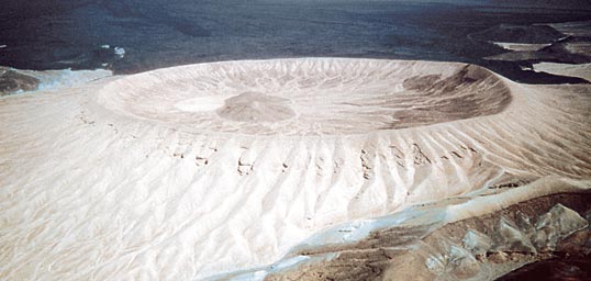 |
The ash crater of Jabal Bayda' ("White Mountain") contrasts so starkly with the surrounding landscape that from a distance it has been mistaken for a snow-capped peak. It has a smaller but taller neighbor, Jabal Abyad (not shown), that is also bright white.
SAUDI GEOLOGICAL SURVERY |
The cinders have consumer uses as well: Glowing a pleasant red at 1000 degrees centigrade, volcanic cinders are ideal for lining gas barbecues. As firewood becomes more scarce in the region, kebab restaurants and grills increasingly turn to volcanic stone placed over gas fires. (Curiously, because most people are unaware of the almost unlimited local availability of this material, the stone most commonly used in Saudi Arabian grills is imported from Iceland—giving rise to a local saw equivalent to “carrying coals to Newcastle.”) Medium-sized granules of lava, with good porosity and water-retaining properties, also provide useful horticultural material ideal for arid regions. The SGS office and laboratory complex in Jiddah has healthy trees bedded in cinders that retain water. Yet this knowledge, too, is new: Most Saudi garden suppliers still import the material from Italy. Idris notes also that while the SGS coordinates exploration for mining, it also monitors undesirable environmental side effects. Open excavation of one scoria cone facing the highway linking Makkah and Madinah has already left an unsightly scar; elsewhere, illegal mining and quarrying are creating other eyesores. “Our challenge is to effectively balance exploitation with the need for geo-conservation,” says Idris.
 xploitation of resources on the harraat stems from the surveys of the 1970’s. With technical assistance from the United States Geological Survey (USGS) and the French Bureau de Recherches Géologiques et Minières, the early focus was on the country’s high-value mineral prospects—particularly gold, silver, zinc and lead.
John Roobol is a volcanologist and an advisor to the SGS who has worked in Saudi Arabia since those days, and he has helped survey and map many harraat regions. “This initial phase of extensive geological mapping brought together one of the largest-ever assemblies of geologists in one territory, involving specialists from France, Japan, Germany, Great Britain, Austria, Canada and the United States,” he says. “This was one of the last great challenges left: a pristine chunk of planet Earth with superb exposure, unknown and unmapped. It was a real opportunity and privilege to be part of the effort: This was total geology.”
 |
 |
 |
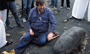
Top left: Mapping the harraat was "one of the last great challenges left on earth," says volcanologist and SGS advisor John Roobol. "This was total geology." Here, he shows a basalt "bomb" that was ejected during an eruption. Bottom left: This and other lava-tube openings may have counterparts on Mars that could shelter future explorers and give insight into Martian geology. Right: Fissures make walking on harraat difficult and hazardous.
SAUDI GEOLOGICAL SURVEY |
The harraat mapping project, under Mohammed Tawfiq of the DGMR, lasted from 1983 to 1991, and for it Roobol and US volcanologist Victor Camp flew hundreds of helicopter hours, surveying from the air and landing on otherwise inaccessible lava fields to take samples. They also made photogeologic interpretations of aerial photographs and satellite imagery. The result was a series of detailed (1:250,000) geological maps and explanatory notes, as well as papers in the international scientific literature covering three of the largest Cenozoic lava fields: Harrat Rahat, Harrat Kashib and the coalesced harraat of Khaybar, Ithnayn and Kura.
“The mapping of the harraat was a surprising success,” recalls Roobol. “Until then they were largely places where no one wanted to go, and at the international level people simply did not know there were such extensive lava fields here. We attended a conference in New Zealand and scientists were surprised. They asked what these poorly known lava fields were doing there, as they were not expected according to new plate-tectonic theories.”
|
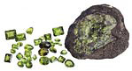 
mbedded within the vast volumes of basaltic lava ejected onto the Arabian harraat are minerals known as xenoliths and crystals called xenocrysts. Derived from the Greek xen-, “foreign,” these terms identify beautiful gemstones, called peridot, that have risen quickly from the magma chambers in the upper mantle during eruptions.
Peridot is the gem variety of the green mineral olivine, and it is now mined on Saudi Arabia’s eastern lava fields, the first commercial extraction of a gemstone from the harraat. The harraat peridots are of high quality, unlike those found buried in soil, whose outside layers become bleached over time.
A much older source of peridot was the small, uninhabited Egyptian Red Sea island of Zabarjad, which provides the Arabic name for the gem. The island lies just 50 kilometers (30 mi) west of the trough that runs down the center of the Red Sea, and it is part of an uplifted fragment of the Pan-African plate into which magmas have invaded. Faceted peridots found in Alexandria and in the ruins of ancient Greece are thought to have come from Zabarjad, which may have been mined for as long as 3500 years. The island has also been called Serpent Isle, due to legendary venomous snakes that were said to attack miners. Mining of peridot continued on Zabarjad until some 60 years ago.
Ranging from a light yellow-green to the intense bright green of new grass to olive, peridot was called “evening emerald” by the Romans, since its characteristic green color remained visible by lamplight. The color is uniquely attractive in arid Saudi Arabia, where green is a much-loved color. (The field of the Saudi Arabian national flag, too, is green.) Because of the way light passes through it, the volcanic gem has a velvety, “sleepy” appearance and a rich, lustrous glow. Saudi gem dealers are hoping that pilgrims to the Holy Cities will find artfully cut and polished peridots an alluring keepsake or a fitting gift. |
As a result of their detailed harraat field work, Roobol and Camp discovered previously unknown continental rifting activity. Postulating a 600-kilometer-long (370-mi) vent system they called the Makkah–Madinah–Nufud volcanic line, underlain by a common “plumbing” system of active mantle upwelling, “we found a north-south trending axis of uplift,” says Roobol—a ridge along the harrah with lavas typical of those in zones of continental rifting. “We discovered that a new fracture with crustal rifting is developing along this axis. It’s entirely different from the Red Sea fault, which is far older: It occurred between 20 and 30 million years ago. This is a much more recent feature: It’s a new fracture developed over the last 10 million years, and it is operating independently from the Red Sea rift.”
Thus the harraat plateau basalts, on the eastern fringe of the Arabian plate, form a volcanic zone distinct from the north-northwest trough of the Red Sea, where active sea-floor spreading continues to form new oceanic crust at fingernail growth rates.
Other features below the harraat surfaces are also just beginning to reveal their secrets. In 2002, SGS surveys located lava tubes—long sinuous tunnels “in the basaltic flows. One, called the Hibashi lava tube, now provides the us National Aeronautics and Space Administration (NASA) with a model for the exploration of Mars and offers earth scientists a new window into Earth’s past.
Mars, too, has lava tubes under the broad basalt plains that may serve as future landing sites, and the lava-tube caverns could prove valuable both for exploration and as possible shelters. “We have become very interested in the Saudi tubes as analogues for Martian lava tubes,” says Penelope Boston of New Mexico Tech, who is conducting Mars studies for NASA. “We suggested that extraterrestrial caves in general would be both very interesting scientific targets for future missions and also excellent future habitat for human expeditions and bases. The (Saudi) lava tubes have been especially interesting because we can see those features on Mars and the Moon.”
 |
| On the outskirts of Madinah, Ottoman forces guarding the holy city dug defensive positions into the rim of this scoria one. |
From a terrestrial viewpoint, Paolo Forti, former president of the International Union of Speleology (IUS), declared the cavern of the Hibashi lava tube, which is perhaps a million years old, to be among the world’s top 10 volcanic caves for rare minerals. In addition, the 580 meters (1900') of passages contain lava stalactites and stalagmites, a floor of silt built up since its formation, bio-stalactites (likely from bat urine) and bones and desiccated scat of wild and domestic animals—many, according to Forti, “perfectly preserved.” These, he says, can “help us to accurately reconstruct the climates of the past to help better understanding of present-day changes.”
From the days when Neolithic peoples harvested black volcanic glass to nap into razor-sharp tools, volcanic Arabia has only begun to reveal its history and its treasures. Today, while machinery clatters at the sides of scoria cones to excavate building materials, and NASA uses lava tubes to model Martian probes, geologists from a new Saudi generation continue to chip away, striving to better understand the Arabian Peninsula’s least-known major geological phenomena. Their efforts reply to the rhetorical question asked by Robert Coleman, a former USGS geologist who studied the rifting systems of the Red Sea and western Arabia: “Is it any wonder that earth scientists from all over the world continue to study one of nature’s great experiments?”
 |
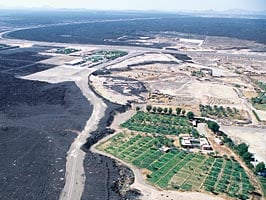 |
| Above left: A "splatter cone," formed by airborne, gooey lava, rises not far from a scoria cone in Hayil region. Top right: A farm, a highway and business centers cut into edges of the harrah near Madinah. While in 1256 the molten lava encroached upon the city, today it is the city that is beginning to flow over parts of the harrah. |
 |
Peter Harrigan works with Saudi Arabian Airlines in Jiddah. He is also commissioning editor of the Anglo-Arab publishing house Barzan (www.barzanpress.com). When not in the Middle East, he spends time at his home on the Isle of Wight. He can be reached at [email protected]. |


