
Written by David L. Kennedy and Andrew Peterson
Photographed by David L. Kenny
 ince the early 20th century, pilgrims to Makkah have sped to their destination in engine-powered vehicles. But for 13 centuries before that, they experienced very different conditions. Makkah lies in the heart of one of the most arid places on our planet, and the surrounding lands from which pilgrims journeyed were often nearly as harsh. Travel was hazardous and fraught with the risks of exhaustion, privation, illness, injury, scant or contaminated food and water, and attack. From the seventh century to the present day, Muslim states have done what they could—and some have gone to great lengths—to minimize these hardships. One way they did this was by offering pilgrims safe stopping places.
As the first Muslim rulers of the Middle East, the Umayyads established their capital at Damascus in the seventh century, making the Darb al-Shami, the “Northern Way,” one of the earliest to be used for the Hajj. There were, of course, far older roads in the region that had been used for centuries by caravans traveling from Yemen in the south of the Arabian Peninsula to Damascus by way of Makkah, Madain Salih and Petra . The Mediterranean coast road was the Via Maris; east of the Jordan River, there was the King's Highway, which ran the length of the plateau; and farther east was the desert track, which provided the most direct route to Arabia from Damascus .
After the coming of Islam, as for centuries before, the choice of routes for the pilgrimage caravans was determined by considerations of geography and security. For long periods, raiders made the desert route unsafe, and pilgrims shifted westward to the King's Highway, which was guarded by fortresses at places like Kerak and Shawbak. But that route involved difficult crossings of the deep valleys that run laterally into the Dead Sea and the Rift Valley—places infamous, too, for their bandits.
| |
 |
 |
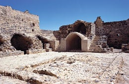
An aerial view of the fort at Qatrana, built in 1559 shows its proximity to the now-dry reservoir. |
Despite recent archeological hints of Roman or pre-Roman use of some of the sites along the desert road, the heyday of this route belongs to the Ottoman period, when it became the principal path both of the pilgrimage caravans and of Constantinople 's communications with its distant Arabian province.
The attractions of the desert route included relatively flat terrain that allowed a swift 34-day journey from Damascus to Makkah. On the other hand, security was always a problem, and water was scarce—but these problems the state could help to solve. Between the 16th and 18th centuries, Ottoman sultans built—or in some cases refurbished—a series of 15 forts between Damascus and Aqaba whose primary function was the protection of the pilgrims' water supplies.
Today, a few of these forts are in the middle of modern towns, but most of them stand alone in the desert. In the last five years, many have been repaired by Jordan 's Department of Antiquities, and there is increased scholarly interest in them all.
| |
 |
|
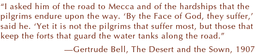
Dating from the 1570’s, the interior of the fort at ‘Unayza was typical: a single wall, a courtyard and a flight of stairs to the garrison’s quarters. |
The Ottoman legacy of the forts began when Süleyman I became sultan in 1520 and expanded Ottoman authority over vast areas that had not been unified under one ruler since the early Islamic period. Süleyman regarded it as his duty to ensure that, each year, the Hajj caravan traveled from Damascus to Makkah and returned again safely. He employed three measures to achieve this goal: an armed, mounted escort (cerde), payments to local tribes (sürre) and the construction of forts. Several of the forts can be dated by inscriptions or literary references, and their character can be explored archeologically.
In 1531 the first Ottoman fort along the Hajj road was built at ‘Ukhaydhir. It was followed in 1559 by fortresses at Qatrana, Ma‘an and Dhat al-Hajj. In the 1570's forts were built at ‘Unayza and Hadiya. Three more forts were added in the 18th century, by which time the Bedouins had acquired firearms, which made them more dangerous than ever to the ponderous Hajj caravan. That fact probably explains the projecting corner towers of these later forts, whose defenders confronted different weapons. Regardless of design, however, all the forts stood within musket-shot of a water reservoir.
Their sizes and floor plans, too, are remarkably consistent: A square or rectangular outline measuring approximately 20 meters (65') on a side encloses a courtyard with a well or cistern and stairs leading to a single upper floor. Although this design has much in common with commercial khans or caravanserais, the forts were built to provide shelter not for the pilgrims but for officials and for the garrison, which averaged 20 men or fewer.
As pilgrims traveled from Damascus, the three principal features of the journey that they encountered were the route itself, the water supplies and the forts. In varying degrees all of those can still be seen today. The route is disappearing with the advance of agriculture and modern roads, but traces survive, and there are some bridges still visible. Most of the forts are well-preserved, and several have seen excavation in recent years and have revealed important information on the neglected Ottoman period and the extraordinary annual event of the Hajj.
| |
 |
|
An aerial view of the fort at Qatrana, built in 1559, shows its proximity to the now-dry reservoir. |
THE PILGRIM ROAD,
DARB AL-SHAMI
 he “road” was seldom more than a deeply worn, unsurfaced track that sprawled over a wide area. This is how Canon Tristram, author of The Land of Moab, saw it in 1872:
We might have been galloping across a deeply ridged fallow. For about a quarter of a mile in width, every three or four yards was a deep wide rut, all in parallel lines. We were crossing the hadj road. Files of hundreds of camels, slowly following each other in the weary tramp to Makkah, had, in course of ages, worn the hard surface of the desert into these deep furrows.
Over 12 centuries, several million people followed the Darb al-Shami on foot, on camels, horses, mules or donkeys, or carried in a litter of some kind. In 1876, when Charles Doughty traveled with the Hajj through Jordan, he estimated that his caravan included up to 6000 people and 10,000 animals, often walking or riding in parallel columns. The photograph, which clearly bears out Tristram's description, was taken 131 years later near the area he described, between the forts of Mshatta and Dab‘ah, in one of the few areas where the old Darb al-Shami has not been smoothed by modern agriculture.
| |
 |
|
|
QASR SHABIB
outh from Damascus, one of the caravans' first stopping places was at Mafraq, which was also a stop on the 20th-century Hijaz Railway. Today Mafraq is a large town, but its fort was destroyed in the 1950's. It is thus at Zarqa, Jordan 's second-largest city, that the first fort south of Damascus survives, an island in the midst of the city. It is a massive, compact tower, a single room with walls three meters (10') thick pierced by arrow slits. Outside are at least three cisterns. The famous Moroccan traveler Ibn Battuta visited it in the 14th century, and it seems to have been originally a Mamluk construction from the 14th century. It commanded a good view from its eminence beside the Wadi Zarqa.
| |
 |
|
|
JIZA
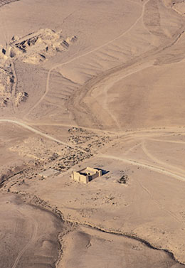
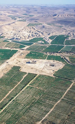
 rom the earliest times, people had tackled the problem of desert water sources by tapping water in winter from natural seasonal watercourses (wadis) and storing it in deep, roofed cisterns or in open tanks. The system could be complex, including dams to divert the water, channels to carry it over distances and settling tanks to allow floodwater silt to sink before the clean water spilled over into the reservoir. The reservoir at Jiza was probably Roman if not Nabataean in origin and is the largest of any from the pre-industrial period in Jordan . It is still capable of holding some 68,000 cubic meters (18 million gal, 55 acre-feet) of water. This view looks southwest over Jordan 's modern Route 25 with the reservoir in the center. The rectangular building on the high ground to its south is the Hajj fort described by Ibn Battuta in the 14th century. It was probably restored in 1569, when the reservoir was certainly extensively repaired, then devastated in 1833 by the troops of Ibrahim Pasha and rebuilt later in the 19th century. It became a post of the Arab Legion and, later, of the Jordanian army. The modern town overlies a considerable settlement from the Roman and early Islamic period.
| |
 |
|
|
QASR DAB'AH
outh of Amman, it seems the Darb al-Shami had alternative branch routes. One passed through Jiza, and another ran farther east through this remote site. The finely preserved doorway opens eastward, looking out over the fertile but dry “pre-desert” beyond.
To the north is a large reservoir, now roofed. This may be the birka (pool) recorded as constructed before the fort, during the reign of Sultan Selim i (1512–1520). The fort itself is 25 meters (81') square and has rooms arranged in two stories around a central courtyard. The square projecting towers, because they are reminiscent of Late Roman forts in this area, have led to the suggestion that this may be a reconstruction of an earlier Roman post. As it stands, however, we can infer some date in the 16th century for its construction—making it one of the oldest Hajj forts in Jordan—as well as repairs carried out in the 18th century. On the south side are traces of a cemetery.
| |
 |
|
|
QAL'AT AL-HASA
he deep gash of the Wadi al-Hasa is one of the great obstacles for travel along the King's Highway, and it helps explain why a desert route, skirting around the wadi at its shallow eastern end, was favored. A glance at the photograph makes clear the significance of the forts, rare places offering security and water.
Until recently, the traveler approaching this lonely site from the north could cross the Wadi al-Hasa by a finely preserved and typical Ottoman bridge. Built by Ayd¦nl¦ Abdullah Pasha between 1730 and 1733, its two main arches spanned 30 meters (97'). The paved road beyond, seven to 10 meters (22–32') wide and extending for 1.5 kilometers (nearly 1 mi), is made of flint cobbles set into square limestone panels. This is one of only two places on the Hajj route in Jordan where the road was actually paved, in this case to prevent the caravan's getting bogged down in the mud that inevitably formed each year after the winter rains. (The other paved section is near Qal‘at Mudawwara in the south, where there are soft desert sands.)
The fort is almost 24 meters (78') square, and it has the typical central courtyard and well with two stories of rooms on each side. The entire north wall has collapsed in recent years, leaving only the vaulted entrance passageway standing until recent restoration. An inscription dates its construction to the reign of Sultan Mustafa iii (1757–1774), making this the youngest of the Hajj forts in Jordan.
Coming in from the east is a channel carrying water from the wadi into the northeast corner of a reservoir. Two more channels lead from the well in the courtyard of the fort to the middle of the west side of the cistern.
When Charles Doughty visited in 1876, the fort was garrisoned by five soldiers, who lived there with their families.
MA'AN
he town is famous for its ancient remains stretching back to Nabataean, Roman and early Islamic times, and lies on a desert route whose use predates Islam. During the medieval period, Ma‘an seems to have been bypassed in favor of a more southerly route via Aqaba, but in the 16th century the Ottomans revived the Ma‘an route, built a fort in the middle of the town and renovated some of the old water systems.
Ma‘an offered a different environment for the pilgrims, who there confronted mud-brick architecture and irrigated gardens resembling those in Arabia to the south: a veritable oasis, with springs and abundant precious water. In 1882, J. L. Burckhardt wrote in Travels in Syria and Arabia Deserta:
The inhabitants cultivate figs, pomegranates and plums in large quantities but they do not sow their fields. They purchase their wheat from Karak, which their women grind: and at the passage of the Hadj they sell the flour as well as the fruits to the pilgrims….
Unsurprisingly, the pilgrims remained for two days at Qal‘at Ma‘an, a relief after the lonely route they had traveled from Syria .
The Ottoman fort, originally built in 1532, is the oldest dated Ottoman building in Jordan . For much of the 20th century, it was a jail, but today it is the local arts center. Immediately in front of the gateway, there is a large reservoir connected to a water channel more than 500.
AQABA
 hen the desert route was too dangerous, the route through Jordan ran farther west through Kerak to join up with the Cairo road at Aqaba on the Red Sea. Here again was an ancient settlement, Eilat and Ezion-Geber, Roman Aila and Islamic Ayla.
Qal‘at al-‘Aqaba is pre-Ottoman, and it is considerably bigger than the other forts, mostly because of its strategic position at the head of the Gulf of Aqaba. A monumental inscription within the entrance to the castle records its construction by the Mamluk Sultan Qansuh al-Ghawri in 1514 or 1515, although recent Belgian–British excavations have revealed that older construction, probably from the early Islamic period, underlies it. Although the fort now stands some distance from the sea, it was originally built next to the beach, which in more recent times has been built up to form a promenade. Opposite the entrance to the fort stands a minaret, which is one of the few reminders of the old town that surrounded the fort in earlier times.
 |
David L. Kennedy is professor of ancient history and classical archeology at the University of Western Australia in Perth . He has taken part in aerial archeology in the Middle East for more than 20 years, having learned the techniques at the side of one of its pioneers, Derrick Riley, flying over the rather different landscape of Yorkshire. His e-mail address is dkennedy@cyllene.uwa.edu.au. |
 |
Andrew Petersen is an archeologist specializing in the Islamic Middle East. He is currently a research fellow at Cardiff University, Wales, and was formerly a research officer for the Amman-based Council for British Research in the Levant. He has specialized in research on Jordan 's Hajj forts since 1986. His e-mail address is petersena@cardiff.ac.uk. |
|
|