
Written by James V. Parry
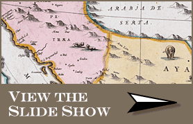
Maps courtesy of the Bukhari Collection of Antique Maps of Arabia
The Arabian Peninsula is a daunting prospect for a mapmaker. Covering more than 2.6 million square kilometers (1 million sq mi) and including today's Saudi Arabia, Bahrain, Kuwait, Oman, Qatar, the United Arab Emirates and Yemen, the Peninsula offers some of the world's most inhospitable terrain. Until the 20th century, the vast sweeps of sand dunes and gravel plains, the roasting heat and the scarcity of food and water proved tremendous obstacles to European travelers in general, and no less to cartographers.
 |
| |
|
  n grade school in Karachi, Pakistan, Marian Bukhari began to scour atlases and meticulously draw maps of places real and imagined, developing what she today calls "my creative obsession with geography." As a young adult, she earned a degree in ancient civilizations, philosophy and English at the University of Punjab in Lahore. In late 1971, as relations between India and Pakistan deteriorated, she and three friends—including her future husband, Saleem—left their homeland by car, just days before war was declared, with the ambitious plan to drive to England. Marian took charge of "navigation, food and itineraries." She recalls sitting with out-of-date road atlases and scribbled notes on sites of historic interest in every country from Afghanistan to France—and it was then she realized that making sense of these was both a passion and a skill. "It suddenly came home to me just how central maps and navigation were to be in my life," she says. "That journey was as much about my own future direction as it was a case of finding the right road between Tehran and Tabrz." n grade school in Karachi, Pakistan, Marian Bukhari began to scour atlases and meticulously draw maps of places real and imagined, developing what she today calls "my creative obsession with geography." As a young adult, she earned a degree in ancient civilizations, philosophy and English at the University of Punjab in Lahore. In late 1971, as relations between India and Pakistan deteriorated, she and three friends—including her future husband, Saleem—left their homeland by car, just days before war was declared, with the ambitious plan to drive to England. Marian took charge of "navigation, food and itineraries." She recalls sitting with out-of-date road atlases and scribbled notes on sites of historic interest in every country from Afghanistan to France—and it was then she realized that making sense of these was both a passion and a skill. "It suddenly came home to me just how central maps and navigation were to be in my life," she says. "That journey was as much about my own future direction as it was a case of finding the right road between Tehran and Tabrz."
 On reaching London, she worked for several charities and soon embarked on a master's degree in anthropology and archeology at the University of London. Saleem took a post in Saudi Arabia, working on city planning for Madinah. His phone calls and letters, with tales of places that to Marian sounded remote and fascinating, inspired her to buy her first antique map of Arabia—a 16th-century engraving based on one by Ptolemy. She found it in a bookshop near the British Museum. This triggered a consuming interest in the cartography of the Middle East in general and the Arabian Peninsula in particular. On reaching London, she worked for several charities and soon embarked on a master's degree in anthropology and archeology at the University of London. Saleem took a post in Saudi Arabia, working on city planning for Madinah. His phone calls and letters, with tales of places that to Marian sounded remote and fascinating, inspired her to buy her first antique map of Arabia—a 16th-century engraving based on one by Ptolemy. She found it in a bookshop near the British Museum. This triggered a consuming interest in the cartography of the Middle East in general and the Arabian Peninsula in particular.
Her quest over the next two decades took her to secondhand bookshops and book and map fairs across Europe, during which time she collected what has turned out to be one of the most important collections of Arabian maps. In 1982 she joined Saleem in Jiddah, from where they began to regularly search for historical landmarks and archeological sites that until then she had known only as names on her maps. "Working from original texts, I was able to retrace the steps of the early explorers and cartographers. In some cases, little had changed since their day. The terrain was just as difficult, the conditions as harsh now as then. I'm left in awe of their dedication and perseverance," she observes.
Today, still resident in Jiddah, she has traveled throughout the Peninsula and her collection exceeds 200 maps. "Little did I know where that first map would lead! It's a fascinating hobby, rediscovering ancient routes and sites under hot, cloudless skies and then following up the fieldwork with map research in cool, musty libraries. It's been an act of love, really, both for maps and for Arabia."
|
| |
|
  ong before the Islamic era, the beginnings of Arab cartography lie in oral traditions and diagrams sketched on skin, bone or wood. The advance of the Arabs under the banner of Islam during the seventh century meant that itineraries and route maps were required for military campaigns: The ascendancy of Islam both reinvigorated scholarship and required more accurate assessments of time and space. Scholars such as al-Fazari, working in the 770’s, compiled astronomical tables based on he movements of the sun and moon that were later expanded into lists of towns, complete with the distances from one to the next and the approximate direction of the roads connecting them. ong before the Islamic era, the beginnings of Arab cartography lie in oral traditions and diagrams sketched on skin, bone or wood. The advance of the Arabs under the banner of Islam during the seventh century meant that itineraries and route maps were required for military campaigns: The ascendancy of Islam both reinvigorated scholarship and required more accurate assessments of time and space. Scholars such as al-Fazari, working in the 770’s, compiled astronomical tables based on he movements of the sun and moon that were later expanded into lists of towns, complete with the distances from one to the next and the approximate direction of the roads connecting them.
During what is often referred to as the golden age of Islam, the Caliph al-Ma‘mun (786–833) sent emissaries from his court in Baghdad to buy Greek anuscripts in Constantinople and beyond, and in this way the cartographic achievements of Ptolemy became known to Arabs several hundred years before their rediscovery by Europeans. Al-Ma‘mun also commissioned a large map of the world, and though it was reputed to have been the best of its era, none of it survives and information about it is scant. (See “The Curious Book of Curiosities.”)
The next four centuries saw a flourishing of Arab cartography during which the Arabs became renowned for both their knowledge of the world and their achievements in a range of scientific fields. The foremost geographer of this period was Abu ‘Abd Allah Muhammad al-Idrisi, born in 1100 in Ceuta or in present-day Morocco. A student at the University of Córdoba in Andalusia, at that time the greatest center of learning west of Cairo, al-Idrisi traveled unusually widely, apparently visiting England, Constantinople and Central Asia. He settled in Palermo, Sicily at the tolerant and enlightened court of the Norman king Roger II Guiscard, where he was charged with the production of a book on geography. It was to contain all available data on the location and climate of the world’s main centers of population. King Roger himself enthusiastically interviewed travelers passing through his kingdom, and agents and draftsmen were dispatched to gather material—a research process that took some 15 years.
In 1154, just a few weeks before the king died, al-Idrisi’s book was finally complete. Written in Arabic and Latin and accompanied by maps, it presented the world as a sphere. It calculated the circumference to be 37,000 kilometers (22,900 mi)—an error of less than 10 percent—and it hinted at the concept of gravity. Following the classical Greek tradition, al-Idrisi had divided the world into seven climatic zones and described each in turn, supported by 70 longitudinal section maps which, when put together, made a rectangular map of the known world. This was complemented by a smaller, circular world map in which the south was drawn at the top and Arabia, being the site of Makkah, was depicted centrally.
Al-Idrisi’s book came to be known as Kitab Rujar (Roger’s Book) and the circular world map was engraved onto a silver tablet. Sadly, both the book and the silver map appear to have been destroyed during civil unrest shortly afterward, in 1160. Thus our understanding today of al-Idrisi’s conclusions is based on an abbreviated version of a second book that he wrote for Roger’s son, William II. Manuscripts of this so-called “Little Idrisi”are held today in a handful of European libraries.
By any measure, al-Idrisi’s work is a milestone in the history of cartography, one that foreshadowed many of the European “discoveries”of later centuries and served as an inspiration for centuries of Muslim thinkers, including the celebrated 14th-century historian Ibn Khaldun.
Yet to Europeans, these revolutionary maps—actually made in a European court—remained unknown for some 450 years, until a version of al-Idrisi’s second book was printed in Rome, in Arabic, in 1592 and in Latin several decades later.
|
| |
|
  espite al-Idrisi's second book, the precise nature and extent of his work and that of earlier geographers remains frustratingly uncertain. With most of the original documents now lost, there is often little or no evidence to help us understand exactly how these scholars of the past pieced together their comprehension of the world. However, in June 2002 the Bodleian Library in Oxford, with the help of Saudi Aramco, acquired through a London antiquarian dealer an 11th-century geographical manuscript that Lesley Forbes, the library's keeper of oriental collections, calls "a unique Islamic manuscript of the first importance, containing a hitherto unknown series of maps and astrological drawings largely unparalleled in any other known sources." It carries the lyrical Arabic title Kitab Ghara‘ib al-Funun wa Mulah al-‘Uyun, or The Book of Curiosities of the Sciences and Marvels for the Eyes. espite al-Idrisi's second book, the precise nature and extent of his work and that of earlier geographers remains frustratingly uncertain. With most of the original documents now lost, there is often little or no evidence to help us understand exactly how these scholars of the past pieced together their comprehension of the world. However, in June 2002 the Bodleian Library in Oxford, with the help of Saudi Aramco, acquired through a London antiquarian dealer an 11th-century geographical manuscript that Lesley Forbes, the library's keeper of oriental collections, calls "a unique Islamic manuscript of the first importance, containing a hitherto unknown series of maps and astrological drawings largely unparalleled in any other known sources." It carries the lyrical Arabic title Kitab Ghara‘ib al-Funun wa Mulah al-‘Uyun, or The Book of Curiosities of the Sciences and Marvels for the Eyes.
Although the author of the book is not known, research to date by Jeremy Johns, Emilie Savage-Smith and Yossef Rapoport of Oxford's Oriental Institute shows that he was well acquainted with both Sicily, where al-Idrisi lived, and Egypt, where, they speculate, the book was compiled. Much of the information draws from Ptolemy's Geographia and other known sources, which the author credits. However, there are other sections, including one on the place-names of the Arabian Peninsula, that carry no attribution and that may therefore constitute original, hitherto unknown material.
Of key interest is an oblong map. It is one of the two cartographic depictions of the world that accompany the treatise. (The other is circular, which was more typical for the period.) Its rectangular shape makes this map unique among those known from its era, even though much of its detail appears to be either derivative or copied. The map is also noteworthy for its lateral scale, which may have made it possible to plot the location of towns from coordinates. This makes it suggestive of modern maps marked with meridians, techniques whose forerunners were proposed in the second century of our era by Marinus of Tyre and later by the 10th-century geographer Suhrab.
 All these are clues that point toward the possible derivation of this oblong map from the lost map of al-Ma‘mun, making it the latest, and most exciting, recent discovery in the ongoing study of the history of the cartographic links between the European worlds. All these are clues that point toward the possible derivation of this oblong map from the lost map of al-Ma‘mun, making it the latest, and most exciting, recent discovery in the ongoing study of the history of the cartographic links between the European worlds.
|
| |
|
 
he earliest navigational instruments were devised to use the sun, moon and stars to calculate location and distance. For more than 2000 years, navigators have known how to deter-mine latitude by measuring the angle of Polaris, the North Star, above the horizon. Such measurements were the basis of early cartography, and Arabs became renowned for their skill in this area, constantly improving the instruments that were used to make these calculations.
Their early tools included the kamal, a small, flat parallelogram with a hole in it, made of horn or wood, with a string threaded through the hole. It was used to measure latitude by fixing the altitude of Polaris. The navigator held a knot in one end of the string in his teeth and drew the string taut with one hand. With the other hand, he moved the piece of horn along the string, closer to or farther from his face, until the bottom edge of the horn was aligned with the horizon and the top edge was aligned with Polaris. He then made a second knot in the string where the horn was. By making the first reading at the time of the ship's or caravan's departure, and by similarly marking and comparing later readings, it was possible to keep track of changes in latitude and thus arrive at a rough estimate of how far the navigator had traveled north or south of the departure point. (Longitude, on the other hand, remained inexact until the 18th century.)
By the middle of the 15th century, similar information was calculated more precisely using a quadrant, a two-part instrument of wood or brass. A plumb bob hung either from a string or from a freely rotating arm and provided a fixed vertical reference against a 90-degree scale whose zero point was sighted on Polaris. The resulting angle was a direct reading of the navigator's latitude. However, the quadrant's dependence on a plumb bob limited its use to land or calm water: it could not be used from a rocking ship.
The most elegant and complex of the instruments was the astrolabe, invented in classical Greece and brought to refinement during the eight and ninth centuries of our era by Arab scientists, who subsequently introduced it to Europe in the early 12th century. Consisting of a framed circular disc, around a series of smaller discs or plates set on a central pin, an astrolabe shows the sky outlined on its face, and the moveable components are adjusted to reflect a specific date and time. Once set, the entire sky, both visible and invisible, is plotted on the face of the instrument and can be used to calculate both distance and direction. With various refinements, the astrolabe remained the most important cartographic instrument up through the 18th century: It was an astrolabe that Carsten Niebuhr used to produce his groundbreaking results in Arabia during the 1760's.
|
| |
|
  ne of the largest publicly available Arabian cartographic collections lies in Riyadh at the King ‘Abd al-‘Aziz Public Library (KAPL). Established in 1985, the KAPL enjoys a growing reputation for the quality of its facilities and collections, the latter ranging from books and manuscripts to coins and photographs. Of particular interest, however, is the library's collection of several hundred maps of Arabia, centered on the 16th to 18th centuries. Since the library's foundation, says Supervisor-General Faisal al-Muaammar, "we were keen to build up a comprehensive collection of maps and charts of Arabia, so that this fascinating material could be made available to scholars and members of the public alike." ne of the largest publicly available Arabian cartographic collections lies in Riyadh at the King ‘Abd al-‘Aziz Public Library (KAPL). Established in 1985, the KAPL enjoys a growing reputation for the quality of its facilities and collections, the latter ranging from books and manuscripts to coins and photographs. Of particular interest, however, is the library's collection of several hundred maps of Arabia, centered on the 16th to 18th centuries. Since the library's foundation, says Supervisor-General Faisal al-Muaammar, "we were keen to build up a comprehensive collection of maps and charts of Arabia, so that this fascinating material could be made available to scholars and members of the public alike."
Although some of the maps were donations, the majority have been acquired on the open market. Represented are many of the top early cartographers, including Abraham Ortelius, Gerard Mercator, Frederick de Witt and Pieter van der Aa. Among the most notable works is an example of Ptolemy's "Sexta Asiae Tabula," published in 1511 in Venice by Bernardo Silvanus in a single edition. Silvanus was among the first cartographers to attempt the updating of Ptolemy's work, and this map shows the Arabian Peninsula, Arabian Gulf, Indian Ocean and the western half of the Indian subcontinent, and it carries an impressive amount of information. It was the first map of its type to be printed in two colors: Black ink illustrated geographical features and minor place-names, while red denoted the more important towns and areas.
 |
(King 'Abd Al-'Aziz
Public Library) |
Al-Muaammar notes that interest in Arabian maps is growing, and the KAPL is thus planning exhibitions in other Saudi cities and possibly elsewhere in the region. "We know that Arabs young and old are interested in seeing how the outside world perceived us and our lands throughout history," he says. "By opening people's eyes to these maps, we hope to bring the past alive for them."
|
This was despite Arabia's millennial roles as a hub of the trade that linked the Mediterranean with India and as a prime source of frankincense and myrrh, essential commodities to the Greeks and Romans. In the seventh century of our era, Islam lent global significance to the cities of Makkah and Madinah, but little of the geographical scholarship that this stimulated, both in the oral traditions of the tribes and in the learned field of Islamic cartography, reached the ears or eyes of Europeans.
Thus the earliest European visitors to Arabia had little to go on beyond hearsay and the reports—often fictional or wildly exaggerated—of those who claimed to have been there before. In its "emptiness," Arabia resembled other places little known to Europeans, such as Africa and China. Only with the unfolding of the Age of Discovery in the 15th century and the advent of scientific cartography did it become possible for the exploration and mapping of the Peninsula to be begun in earnest—a process that, in this new century, is for the first time in the hands of its own people.
he story told by the Marian Bukhari Collection of Antique Maps of Arabia actually begins almost 2000 years ago with the "father of cartography," Claudius Ptolemy. A Greek resident of Alexandria in Egypt, he was responsible for the famous library there from ad 127 to 150. Building on work by earlier scholars, notably Strabo and Eratosthenes, Ptolemy compiled a gazetteer entitled Geographia. It was an ambitious attempt to catalogue all of the known world's place-names, some 8000 in all. Much of the information in the portion of the directory devoted to the Arabian Peninsula also drew on the accounts of Greek sailors, who were especially familiar with the Red Sea coast and who had heard stories of interior towns from the local inhabitants of the ports. But the secondhand nature of such information, in which the location and distances between towns were based on unfamiliar standards such as the length of camel marches, meant that many of Ptolemy's efforts were little more than guesswork. Even so, they represented the most advanced account of the world's geography at that time.
He accompanied the Geographia with a map of the world, together with a series of between 26 and 64 regional maps. Neither the exact number of these nor their precise content is known, for all of the original components of the Geographia were lost, possibly not long after their completion. Copies, along with works by others that were based on the originals, were used by Arab scholars from the eighth to 12th century in laying the foundations of their own cartographic tradition. (See "The Triumph of al-Idrisi.") Yet outside the Muslim lands, Ptolemy's achievements remained forgotten until the Arabic versions were translated back into Greek in the 13th century and thence into Latin by the early 15th century. Although full of errors and "improvements" of dubious factual value, these re-translations of Ptolemy served as the single greatest source for the rash of new European maps that appeared in the last decades of the 15th century, thanks in large part to advances in the craft of printing.
Two of Ptolemy's maps that came down through this chain of transmission showed Arabia, and they mark the first time that the shape and topographical character of the region is known to have been depicted. One of these maps covered the areas known as Arabia Petraea and Arabia Deserta, placing them in present-day Iraq, Jordan and the Levant. The other featured Arabia Felix and applied the term to the whole Peninsula, rather than to the southern portions of it. The maps were first printed in Bologna in 1477, the culmination of a fiercely competitive race to publish versions of Ptolemy's works following their rediscovery. Plenty of mistakes were made in the rush, even extending to the incorrect printing of the date, but the maps made a dramatic impact nonetheless, and their accuracy remains an impressive achievement. Geographical parallels and meridians—forerunners of lines of longitude and latitude—had been established by Greek scholars by the end of the third century bc, and Ptolemy made good use of this knowledge, drawing (or, more probably, instructing his draftsman to draw) a fairly coherent representation of the Peninsula.
Although Ptolemy overestimated both the width of the southern part of Arabia and the size and shape of the Arabian Gulf, his overall form of the Peninsula, as distilled and represented by late 15th-century European cartographers, was hugely influential, and it served as a standard to which European maps of the region adhered for many years. This legacy is well represented in the Bukhari Collection: One of the best examples is "Tabula Asiae VI," published in Basel in about 1540. This map highlights the rather square shape Ptolemy gave the Arabian Gulf and includes a cartouche giving the names of local tribes. However, as with many early maps, towns are placed only very approximately.
 y the early 16th century, the boundaries of European geographical knowledge and experience were expanding rapidly. Most mariners had access to portolans, charts made for sailors showing exclusively coastal features such as ports, river mouths, reefs and sandbanks. Portolans became increasingly accurate as nautical use of the compass and other instruments improved. (See "The Cartographer's Tool Kit.")
The larger impetus for this exploration was, of course, trade and the profit it could bring. The quest for opportunities made ever more detailed knowledge of the world both essential and possible. This era proved to be a turning point in cartography, as the crowned heads of Europe vied with each other in granting patronage not only to the explorers, but also to the growing guilds of mapmakers and printers who with poised pens awaited the return of expeditions from terrae incognitae.
New maps were published frequently at this time, and earlier ones were subject to regular revision. In 1548, the Italian Giacomo Gastaldi published "Arabia Felix Nova Tabula," the first to be focused specifically on Arabia. Cartographic historian Gerald Tibbetts, author of the 1978 book Arabia in Early Maps, regards it as the first truly modern map of the Peninsula. Not only was Gastaldi able to present Arabia 's shape and orientation more accurately than Ptolemy, but he also confidently plotted certain coastal towns—Jizan was one—for the first time, though much of the inland detail remained arbitrarily drawn. It even included an enticing—but totally fictitious—lake, Stag lago, in the middle of the Rub' al-Khali, a feature whose genesis lay in an area of water marked by Ptolemy, but expanded by Gastaldi and propagated by other wishful-thinking cartographers after him until its eventual deletion during the 17th century.
Such errors were commonplace. Indeed, the variable quality of early maps meant that cartographers working from more than one source were liable to compound the errors of their predecessors. Gastaldi himself plotted two Hadhramawts. Nor did draftsmen allow their ignorance of a particular region to inhibit them, often filling areas of uncertain content with entirely fictitious and exaggerated features or obscuring them by a conveniently placed cartouche.
 astaldi's work notwithstanding, during the 16th century it was unusual for Arabia to appear as the sole or even primary feature of a map. The heyday of the incense trade was long gone, and Europeans generally wrote off the Peninsula as a sandy and unprofitable waste compared to the promise of silver, gold, diamonds, ivory and exotic textiles from the Americas, sub-Saharan Africa and India. Additionally, since the 16th century, the coastal fringes of the Arabian Peninsula had been a part of the Ottoman Empire. From their capital in Constantinople , and through their control over much of the Balkans, the Ottoman Turks exerted enormous political and cultural power, and their power generally defined western depictions of the region. By the 17th century, tales of exotic dress and customs had fueled the European imagination, and cartographers responded. Maps and atlases had become important conduits of information about distant lands and peoples, and privileged access to such information was something for which customers were prepared to pay.
Such commercial considerations must have been in John Speed's mind when he prepared his 1627 copper-plate engraving "The Turkish Empire" as part of his book Prospect of the World. One of the most visually impressive of all the maps displayed in the Bukhari Collection, it is a beautiful work, adorned with depictions of eight cities and careful vignettes of "typical" local costumes. In practical terms, this map also illustrates how the understanding of the general shape of Arabia had improved by this time.
In the early 18th century, Dutch interest in the region grew along with Dutch commercial activities in the East Indies. Cartographer Pieter van der Aa produced maps as attractive as Speed's, although his technical accuracy was arguably less assured. His works include "De Roode Zee met de Kusten van Arabien," a 1707 map of Arabia and the Red Sea, complete with an elaborate cartouche showing exotically dressed locals.
By this time European knowledge of the coastlines of the African continent and India had advanced considerably, and the interiors of these lands were beginning to be sketched along the courses of navigable rivers. But with no rivers up which to venture, Arabia was doubly difficult to chart, and the locations of inland towns remained largely speculative, the subjects of unreliable and often conflicting reports.
 s the 1700's progressed, the application of a more scientific approach to education and learning extended to cartography. The desire to put mapmaking on an empirical basis that would reflect measured realities rather than hearsay or estimates became the catalyst for the creation of the "scientific expedition." The first of these to be dispatched to Arabia went in 1761 at the behest of Frederick v, king of Denmark and a noted patron of the arts and sciences. Charged with conducting a rigorous survey of the physical Peninsula as well as its people, flora and fauna, the expedition included a doctor, a botanist, an artist, a philologist, a surveyor and a manservant. Only one returned alive: Carsten Niebuhr, the surveyor. His work, and that of his comrades, was to have a lasting impact.
The Danish party sailed to Arabia via Egypt, where Niebuhr calculated the height of the Pyramids and plotted the Rosetta branch of the Nile so accurately that his plans were used more than a century later in the construction of the Suez Canal. After making landfall close to Jiddah, where they spent six months before heading south to what is now Yemen, the members of the team got down to their respective tasks. For his part, Niebuhr set off from camp each day by donkey with his surveying equipment, which included a compass and an astrolabe, as well as a sabre and two pistols. His activities caused some consternation among the local populace —especially when he invited them to look through the astrolabe’s viewfinder, which displayed the subject upside-down—but the painstaking results he produced set exacting new standards and laid the scientific foundation for later expeditions to Arabia and elsewhere. Throughout his travels he maintained a meticulous diary, complete with sketches and measurements, which, after he returned to Europe in 1767, provided him with the material to produce a series of detailed maps of southwestern Arabia and of the towns he had visited there.
London antiquarian map dealer Jonathan Potter views Niebuhr’s work as a watershed: “He really moved Arabian mapmaking into a new league. No one had gathered data so scientifically before. He had such a grim time, constantly falling ill, being stoned by unfriendly locals, his colleagues dying around him, and yet he stuck to his task and refused to give up.”
Two masterpiece maps in the Bukhari Collection exemplify Niebuhr’s contribution. The first, by him, is “The Red Sea or Arabic Gulph,” a copper-engraved and hand-colored map of such precision that it was still being used by the British Royal Navy a century later. The second demonstrates his influence: In 1751, a decade before Niebuhr’s expedition set out, Jean-Baptiste Bourguignon d’Anville, a scrupulous French cartographer working from the maps of al-Idrisi, among others, had produced a map of Arabia in which he applied the latest scientific knowledge and corrected errors that had been perpetuated in maps of the region for many decades. Rather than filling those areas he was unsure of with imaginary information, d’Anville pointedly left them blank. Indeed, it was partly the desire to fill such gaps that prompted the Niebuhr expedition. Accordingly, a revised version of d’Anville’s work was published in 1794 with the inscription “A New Map of Arabia, with additions and improvements from Mr. Niebuhr.”
ecause Europeans did not travel them, the old incense trails and the well-worn pilgrimage routes to the Holy Cities—frequently one and the same —were often neglected. It was not until the early 19th century that European acquaintance with the Arabian interior became sufficient to allow cartographers to plot these longstanding routes with confidence. One example is the map by an unknown draftsman published by Waugh & Innes in 1820 in England : " Arabia, Hajj Routes from Sham, Bagdad and North Africa." On it appear the main pilgrimage routes, with clear annotations of their origins, such as "Route of the Indian Caravan." An early example of a map reproduced by lithography, its focus on the Hajj and Islam also reflects the burgeoning contemporary interest in the region and its culture, part of the trend that came to be known as Orientalism.
By the mid-19th century, there was an upsurge in the accuracy of map data, as the fruits of scientific enquiry helped provide the missing pieces of the global jigsaw puzzle. In Arabia, much of this progress hinged on the discoveries of other explorers such as Johann Burckhardt, William Palgrave, Richard Burton and Charles Doughty. Irascible and judgmental, Doughty traveled in what is now Saudi Arabia during the 1870's, and although his scientific contribution was ignored or even scorned by contemporary academics in his native England, he was central in recording the topography and the toponyms of Arabia's interior. Doughty had the patience and dedication to record the factual knowledge that for so long had resided solely with the people that knew this region best—the Bedouins. He accurately noted down local place-names, as well as the locations of wadis and other topographical features, often supporting these with sketch maps, which he discussed with the Bedouins with whom he traveled. He had little regard for earlier mapmaking attempts: "The work of the cartographers in construing many unintelligible names of which no man in the country had ever heard, I found…to be commonly of little worth."
oughty's efforts represented another watershed: Though he was a European, his work marks the first time Arab knowledge of the interior of Arabia had been systematically recorded and made available to other Europeans—in theory at least—through the mapmaking process. Despite the great achievements of Arab scholars such as al-Idrisi in earlier centuries, Arab input into the mapping of the Peninsula had been negligible until Doughty's time—simply because the local population had little need of maps, which were rightly regarded as a European obsession. Sadly, however, few of Doughty's records ever made it to the cartographic studio, and the potential of his achievements was not recognized until decades later, when he came to be admired by early 20th-century travelers to the region, among them Capt. William Shakespear and T. E. Lawrence, both of whom were active in mapping as well as other pursuits.
Chronologically, the Bukhari Collection ends here, with a 1901 lithograph of the Red Sea. It is a suitable juncture at which to pause, for the ensuing decades saw tumultuous change in Arabia. In the run-up to World War I and the demise of the Ottoman Empire, the region was the subject of bouts of military cartography as the colonial powers struggled to understand the terrain over which they were arguing. Interestingly, even in the early 20th century the precise scientific coordinates of such prominent towns as Madinah remained unknown to the European powers.
he upheavals of this time also heralded the re-awakening of Arabia 's aspirations to autonomy, most significantly under the leadership of King ‘Abd al-‘Aziz Al Sa‘ud, who unified much of the Peninsula and proclaimed the Kingdom of Saudi Arabia in 1932. Unification and the end of intertribal disputes placed responsibility for the welfare of the new kingdom and its people squarely on ‘Abd al-‘Aziz's shoulders, and one of his most immediate concerns was to ascertain what the country's assets and resources were.
Although the search for oil, gas and minerals was ultimately to drive geological survey work across the region—and still does today—in its early years it was the need for water that was the catalyst for Saudi Arabia 's resource exploration. In 1944 King ‘Abd al-‘Aziz approached the United States for a technical expert who could assist with the identification and plotting of the kingdom's natural resources, particularly its groundwater reserves. The individual who arrived, Glen F. Brown, was one of the pioneers of a partnership between the United States Geological Survey (USGS) and the government of Saudi Arabia that was to span the next five decades and play an important role in the development of the kingdom. Brown was initially charged with carrying out surveys of much of western and central Arabia, and he gathered his information in much the same way as earlier travelers. Using modern equipment, but still traveling part of the time on foot or by donkey, Brown and his companion, Richard Bramkamp of Aramco, measured temperature and humidity, identified and estimated the extent and quality of water and mineral resources and calculated topographical data. It is estimated that the two covered more than 38,000 square kilometers (15,000 sq mi) in little more than 18 months—an extraordinary achievement.
Soon afterward, such work was dramatically supplemented by aerial photography, and by 1954 the Saudi Ministry of Finance, USGS and Aramco were working together to produce the first full series of geographic and geologic maps of the country. The first of their type in the Peninsula, these were published between 1960 and 1963 in both Arabic and English versions, and the information they contained formed the basis of subsequent Saudi national development plans. To this day, all modern maps of the kingdom trace their roots back to these first publications.
The USGS continued to play an important role over the next 40 years, a time during which its responsibilities evolved from basic mapping and exploration to technical surveys to develop the Saudi mineral sector and search for geological hazards, a process in which the work of the cartographer has come to overlap with that of the geoscientist. Throughout this period, as part of its partnership, the USGS emphasized the development of Saudi technicians and administrators, something that Ronald G. Worl, former USGS mission director, regards as "one of the most rewarding achievements" of his job. In 2001, the Saudi government opened the doors of the Saudi Geological Survey (SGS), and the USGS closed its mission's doors last year.
The new generation of Saudi cartographers and of domestically published state-of-the-art maps adds the most recent chapter to the history of the mapping of the Arabian Peninsula, a process begun by Ptolemy more than 2000 years ago. The efforts of generations of explorers, mariners, merchants, scholars, surveyors and geologists have charted one of the world’s great landmass interiors, creating along the way a direct pictorial link with the past. As works of both art and science, the historic maps of the Peninsula show more vividly than words how Arabia unfolded in the European consciousness as the result of trade and exploration, a thirst for knowledge and no small amount of courage and ingenuity. Now collected, arrayed and available for study, the maps of the Bukhari Collection and others stand as tributes to their makers: the diligent and the imaginative, the curious and the intrepid.
 |
Free-lance writer James V. Parry (jamesvparry@aol.com) served several years with the British Council in East Africa and Oman. He writes on the history and cultures of the Arabian Peninsula from his home in Norfolk, England. |
|
|