
Written by Graham Chandler
Photographed by Michael Nelson
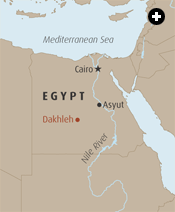 The Western Desert of Egypt, near the Dakhleh Oasis, appears to be one of the most uninhabitable places on the planet. Any search for signs of life on this Martian surface seems pointless. But as we crest a ridge of sand, with chunks of ironstone clinking underfoot, archeologist Mary McDonald is about to show me something that puts paid to that notion: evidence that she has found not only the beginnings of settled life in North Africa, but almost certainly the beginnings of the longest-lasting civilizationthe world has ever known—the Pharaonic, or Dynastic, civilization of the Nile Valley, heretofore thought to have derived from elsewhere in the Middle East.
 |
 |
 |
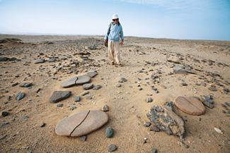
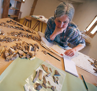
Top: Senior archeologist Mary McDonald of the DOP views Neolithic grinding stones in the desert near Dakhleh. From the characteristics of a society’s “tool kit,” archeologists can tell much about the people’s economy and mobility: Sedentary cultures tend to have heavier, more specialized tools; nomadic ones lighter, multipurpose or disposable tools.
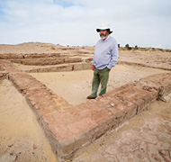
Left: Anthony Mills founded the Dakhleh Oasis Project (DOP) in 1978. Since then, it has hosted dozens of specialists from around the world to study the relationship between the land and its inhabitants from 400,000 years ago up to the Roman era.
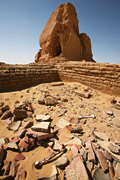
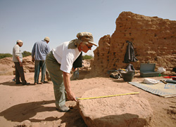
Right: At the ruins of an Old Kingdom pyramid at Amheida, one of the numerous archeological sites around Dakhleh, archeologists will sift ancient debris to determine which fragments and artifacts will be analyzed.
|
 cDonald, a petite and sprightly Canadian with gray streaks in her long black hair, wears a broad smile underneath her straw hat and a Foreign Legion-style bandana. Her delight comes from telling me about the scene that now lies before us: hundreds of round, oval and rectangular spaces the size of camping tents, defined by flat stones stuck on their edges in the sand, many with flagstone floors about 30 centimeters (12") below ground level. They’re clustered in what may have been a village the size of three football fields. “Many hundreds of people lived here,” she beams. “It’s the largest Neolithic site in Africa.”
The question of where the great Pharaonic civilization came from and how it arose has never really been answered, not by the ancient Greeks nor by the first European explorers and archeologists, who explored and plundered it in the 19th century. Until just a few decades ago, the received wisdom was that a “superior culture” must have invaded Egypt, or migrated there, from the Levant or Mesopotamia—regions that had civilizations a thousand years earlier. But for more than 200 years, precious few archeologists had the inclination to explore this question of origins: Most were more dazzled by the mummies, temples and tombs.
It was just a few decades ago that Anthony Mills sat spellbound at a lecture by the late Egyptian archeologist Ahmed Fakhry at Toronto’s Royal Ontario Museum, where Mills was serving as an assistant curator. Mills was also a keen archeologist fresh off the Nubian salvage campaign of the 1960’s and 1970’s, and he was casting about for a long-term project. After the lecture, Mills managed to corner the famous Egyptian, who had accompanied the first world tour of King Tut’s treasures. Fakhry, it turned out, had done some preliminary archeological exploration in the  Western Desert around Dakhleh, and he suggested to Mills that Dakhleh might be just what he was looking for. “It stuck in the back of my mind for a long time,” says the affable Mills.
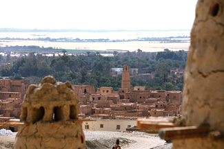
The modern-day Dakhleh Oasis lies 800 kilometers (500 mi) by desert road southwest of Cairo, and it is the largest of the five major oases of the Western Desert. Lying about the same latitude as Luxor, its 80- by 25-kilometer area (50 by 15 mi) boasts 75,000 inhabitants who produce wheat, mangoes, oranges and dates. Fodder-laden donkey carts, their turbaned drivers occasionally chatting on their cell phones, are a fine contrast to the cacophony of downtown Cairo.
 |
 |
Above: Mainly known for its wheat, mangoes, oranges and dates, Dakhleh is the largest of Egypt’s five “Islands of the Blessed,” oases deep inside the Western Desert, which is part of the Sahara.
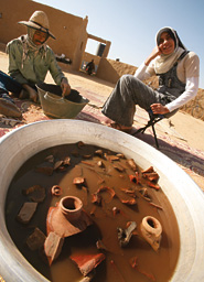
Left: In the compound that houses the DOP, local workers wash artifacts.
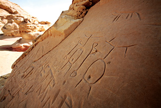
Below: Rock art appears near a circle of ruined stone huts that likely date from the early Neolithic. |
 |
Mills and his colleague Geoffrey Simpson journeyed to this cornucopia in 1977, after obtaining permission to look at an Old Kingdom site there. After they had walked for a few weeks on the desert surface, it quickly struck them that Fakhry was right. Their trained eyes recognized fragments from every period of human existence, from the Old Stone Age right through to Roman and Ottoman times. “It didn’t take long to realize that a nice big-area approach was in order,” says Mills.
Back in Canada, they recruited several researchers. Many, like zoologist C. S. “Rufus” Churcher and anthropologist Maxine Kleindienst from the University of Toronto, are now, along with McDonald, senior researchers who have been back every year—this year marked the 27th season of the Dakhleh Oasis Project (DOP) that Mills started in 1978.
Today the DOP is not just archeology, but a long-term regional study of the interaction between environmental change and human activity in the oasis from 400,000 years ago to the third century of our era. To assemble the whole picture, the project has attracted geologists, geomorphologists, botanists, zoologists and more from countries as diverse as Australia, Canada, the US, Germany, Poland and Switzerland. They make their temporary home at the DOP’s villa just a few kilometers from Dakhleh’s capital, Mut, on the road to Sheikh Wali. A pleasant mud-brick compound housing labs, offices and rooms for 35 researchers, the villa sits on a hill called Ain el-Gindi. The DOP has produced over 300 academic papers and 15 books, not to mention a dozen or so graduate degrees. “Our ultimate aim is to write a synthesis of the complete record of man’s adaptation here,” says Mills.
That record apparently starts in the 400-meter-high (1300') limestone-capped escarpment that dominates the entire oasis to the north. It is on these cliffs that Kleindienst and McDonald have found crude stone hand axes—a tool made by humans in the Paleolithic period at least 400,000 years ago.“I say ‘at least’ because the tufas[calcareous deposits laid down during wet climatic periods] can’t be dated past that,” says Kleindienst, who’snow retired from the University of Toronto’s Department of Anthropology. But the same formations told her there was a supply of artesian water then that supported human habitation right up till the appearance of modern humans some 20,000 years ago. Then, it appears, the climate dried up, game disappeared and plants died out, forcing people to abandon the Dakhleh area for the next 10,000 years. Then, about 10,000 years ago, they came back when the water returned, starting a sequence of human cultures that, as McDonald is discovering, played a major role in the birth of the spectacular Pharaonic civilization.
For the first five years, DOP researchers spent countless hours just scouring the desert topography around Dakhleh, meticulously recording fragments of bone, stone tool chips and pottery sherds. McDonald, for her part, would start before sunrise each morning and walk into the rising sun to catch the glint of fine-grained chert fragments that would tell her the story of the gradual rise of sedentism in the area—indications that people were growing less mobile, a trait that could have profound implications for the emerging debate about the start of settled village life. (Sedentism, or sedentarism, is the term archeologists use to describe the process of settling down.)
 |
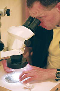 |
| Left: In the DOP lab, McDonald categorizes some of the project’s thousands of artifacts. Right: Examining trace plant remains, archeobotanist Johannes Walter matches samples to lists of known wild and domesticated species. |
In the mixture of surface artifacts, she could gradually distinguish a number of distinct cultures based on their “tool kits.” The earliest appeared to be one of a highly mobile people, which she dubbed “Masara,” after a nearby village of that name. Their portable, possibly disposable, small stone blades were the archeological markers of small bands of hunter-gatherers ever on the go, following game and harvesting wild plants in seasonal rounds. The Masara seem to have appeared on the scene around 9500 years ago, and they wandered the desert for a few millennia before even temporarily settling.
Archeologists infer just how mobile groups are from their “tool kits.” As people start living a more settled life, they develop new technologies. Instead of manufacturing recyclable and multiple-use tools that are easily carried, more sedentary peoples make larger and more specialized tools: Think of the difference between a multi-function pocketknife and a workshop’s tool rack.
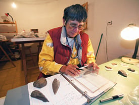 |
| Also a senior researcher at the DOP, anthropologist Maxine Kleindienst has discovered crude stone hand axes in Dakhleh that date to 400,000 years ago. |
With this notion in mind, McDonald noted a gradual change in the Masara tool kit, which became larger and more varied over about 1200 years. She suspected this meant the Masara were probably moving less and less around the savannah, as it was then. But she had little to go on but the more cumbersome tool set.
Then, in 1990, one of her students, Greg Mumford, stumbled upon some 17 stone circles on one of his desert forays. McDonald was delighted. This grouping of stones contained Masara tool types, and she knew immediately what that meant: The Masara were settling down for at least part of the year. The proof was more than the semi-permanent huts these circles implied. Attached to some of the circles were storage bins, and inside were grinding stones. Arrowheads and stone scrapers were found, along with bones of wild game. The circles were dated to 8800 years ago, during a short dry interval. McDonald hypothesizes that the Masara were “dusted out” of the desert and came to spend more time at the oasis. The remains implied they didn’t live here year-round because “their [shelters’] upper structures would have been too flimsy.” But she was all smiles. Here she had defined the first evidence of the Neolithic era in North Africa: These are the first known purpose- built stone structures on the continent. But staying in one place part of the year doesn’t always mean the Neolithic Revolution is coming. Examples abound of peoples staying put for most of their lifetimes: The lush northwest coast of North America had enough fish and game to sustain four seasons’ living, and yet no Neolithic Revolution ever happened there. Nor did it happen in the Nile Valley of 7000 or 8000 years ago, as researcher Michael Hoffman discovered in his excavations at the site of Hieronkopolis. McDonald needed more. She needed evidence of some further progress past mere sedentism, such as animal or plant domestication.
 |
 |
| Top: Plant remains are sorted prior to examination. Bottom: Neolithic artifacts made from materials that include carnelian (left), azmonite (right) and stone (upper and lower). |
Meticulous examination of the Masara hut circles had yielded bone and seed remains, but Churcher, the project zoologist with a long background in Africa, admits that pronouncing a species wild or domestic just from bone remains is problematic. “But this assemblage was clearly wild animals that were never domesticated—hartebeest, gazelle, birds, hare and the occasional tortoise or toad,” he says.
Nor was pottery, another sign of sedentism, ever found at the Masara circles. And charred plant remains proved to be from wild grasses and portulac, a moisture-loving herb still eaten here today, that were likely harvested and ground up with the grinding stones.
The key Neolithic marker was yet to come.
It came for McDonald in the same momentous year, 1990. “I was at dinner and Lech Krzyzaniak [who was studying rock art there] told me about this mysterious large stone ring he had spotted on an aerial photograph,” she says, her scarf flapping about her face. Krzyzaniak had checked it out and on the same outing had found a new collection of hut circles, the ones that now lie before us in the drifting sand. “I had some work I wanted to finish up on my Masara hut circles first,” she recalls, but “they frog-marched me over there the next morning.”
McDonald was blown away—this time not by the incessant wind but by instant recognition of the importance of the find. Walking today among these enigmatic circles, she bends over and picks up a tiny trapezoidal piece of ostrich eggshell the size of a cornflake with a neat, countersunk hole drilled through the middle. “There was enough stuff that just jumped out at me,” she says with an even broader grin.
 |
|
 vidence of settled life, or sedentism, is very important to prehistoric archeologists. It’s the first signal of the Neolithic Revolution, which is probably the most significant and momentous of all changes in the record of humankind. After several hundred thousand years of living in small nomadic groups, in relative symbiosis with the animals they hunted, lifestyles changed radically. First occurring around 10,000 years ago in the Levant, settled life led to changes in diet; the domestication of animals and crop plants; pottery; materialism; complex social organizations; increased territoriality and organized warfare; monumental architecture; and, eventually, writing. In short, all of the world’s civilizations started with the critical decision to stay put. vidence of settled life, or sedentism, is very important to prehistoric archeologists. It’s the first signal of the Neolithic Revolution, which is probably the most significant and momentous of all changes in the record of humankind. After several hundred thousand years of living in small nomadic groups, in relative symbiosis with the animals they hunted, lifestyles changed radically. First occurring around 10,000 years ago in the Levant, settled life led to changes in diet; the domestication of animals and crop plants; pottery; materialism; complex social organizations; increased territoriality and organized warfare; monumental architecture; and, eventually, writing. In short, all of the world’s civilizations started with the critical decision to stay put.
|
This “stuff” was of a culture much more advanced than the Masara. In her initial years of scouting the desert, McDonald had identified and defined a separate culture she had placed later than the Masara. She hadn’t yet named it, but she knew it was quite separate from the Masara, and, importantly, it was more advanced technologically. The unnamed culture had pottery, fine leaf-shaped arrowheads, pleasing smooth stone tranchets for scraping, toggles of fine sandstone—what these were used for she hasn’t yet figured out—and elaborate jewelry-like marine shell bangles and beads of carnelian. When she saw this site, she knew the culture needed a name. “This site is Bashendi,” she says, reaching for a sandstone grinder that fits neatly into her palm.
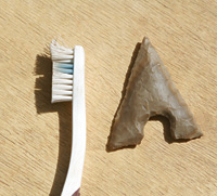 |
| A well-preserved Neolithic arrowhead. |
Pointing out the smooth side, she says the Bashendi would have used these to grind local wild millet and sorghum. We trudge through the hard-packed sand with its wind-formed ripples to a circle she has excavated. “See how the walls on the north side are heavier, more reinforced,” she says. It implies the huts were occupied during the winter months of north wind. Most of the structures are round or oval and three to five meters across (10–16') but about a third of them are rectangular. Some have flagstone floors, and McDonald points out a crumbly material that may have been used to chink walls against the chilly wind. “Let’s go over the next couple of ridges. There’s something else I want to show you,” she says.
Over the second ridge lies the large circle that Krzyzaniak first spotted. It’s half the size of a football field, slightly oblong. McDonald walks around it, pointing out “entrances” in the two-meter-thick (6'6") walls that stand up to a meter high. What are your thoughts about what it was used for, I ask. “Local barn dance?” she quips mischievously. Then, seriously, “More likely an animal enclosure of some kind.” She points out that one of the entrances has a built-in enclosure like a hut circle: shelter for a herdsman, perhaps?

Though it seemed a logical conclusion, she has found precious little evidence of what the large structure was really used for. “We found no post holes,” she says, “which you’d need if a structure this size were covered over.” She’s hoping to obtain some chemical or mineral studies that might tell her of animal-dung residues. But some proof comes from Churcher’s analysis of the teeth and bones collected from the first Bashendi site we visited. “The Bashendi had goats and cattle,” he told me earlier in his lab. “Whether they’re wild or domestic, though, we can’t really tell at this point. It can take up to a thousand years for the physical traits of domestication to show up in the record. But their teeth were well worn, and they were frequently older animals.” He went on to explain that this usually points to domestication—older animals wouldn’t normally be hunted. And it would indicate the animals weren’t kept for their meat, but more likely for blood and milk, the reasons the modern Masai to the south keep cattle.
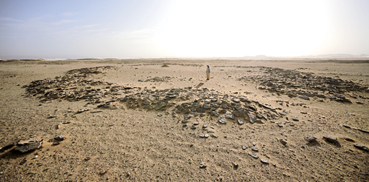 |
| The first material evidence of the connection between the desert and the pharaohs came from the several dozen “Bashendi” settlement ruins, spotted in 1990 and analyzed over the past decade. At this animal enclosure, McDonald found evidence of goats and cattle some 6500 years old; in others, she found tools and jewelry that resembled artifacts from sites almost due east along the Nile. |
McDonald agrees the Bashendi were cattle-herding pastoralists. It would make sense as a way to adapt to a changing climate, something that’s been observed in other parts of Africa. She has also seen a close correlation between changes in the ancient climate and the way Dakhleh’s people adapted. Studies have shown that around 6500 years ago the Monsoonal Belt started moving south, letting the desert encroach and forcing residents to adopt pastoralism to survive. A secure source of animal products would be needed as wild fauna became stressed or drifted south. Cattle, already native to North Africa, were the easiest to domesticate. As the Bashendi began to dominate the water holes of the oases, wild animals would have been crowded out, forcing the Bashendi to rely still further on their cattle herds.
The Neolithic Revolution of the Western Desert was under way.
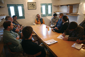 |
| Archeologist Colin Hope gives a lecture on pottery to young archeologists visiting the DOP. |
When McDonald was working late into the night pulling together her Bashendi artifacts and defining the culture’s distinguishing features, Mills had observed over her shoulder more than once that many of the objects seemed to have parallels in artifacts excavated decades earlier in the Nile Valley. Distinctive side-blow tools (so called because the tool is made by striking the side of a stone material instead of the usually more efficient top), labrets (probably for lip decoration), hollow-based arrowheads and jewelry such as marine-shell bracelets and beads of amazonite and carnelian were similar to some dug up at sites like Badari and Mostagedda, near the present Nile-side city of Asyut—the closest point on the Nile to Dakhleh. This piqued McDonald’s interest.
Back at the University of Calgary, she looked up the excavation records of Sir Flinders Petrie, the “Father of Egyptian Archeology” of the late 1800’s and early 1900’s. Petrie had earned his title well with his meticulous, systematic excavation recording that’s still used today as a model for students of archeology. His findings around the site of Badari came to define the “Badarian,” which was the first phase of the Predynastic period—forerunner to the well-known greatness of the Dynastic era.
While McDonald wasn’t the first archeologist to sense a connection between Dakhleh and the Nile Valley, never before had such solid evidence been available as a Neolithic village with domestication of an animal species. She delved more deeply and in 1989 presented a well-received paper at a Toronto conference. After the 1990 season, with the hut circle and domestication discoveries, it was surely possible that the Bashendi of the Western Desert were part of the Neolithic Revolution in the Nile Valley.
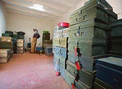 |
| Artifact cases stacked shoulder high at the DOP. |
It remained to date those Bashendi items that also occurred in the Nile Valley. McDonald chose some ostrich eggshell excavated from the Bashendi circles. The dates that came back from the radiocarbon lab confirmed her hypotheses: Nearly all of the shared artifacts showed up in Dakhleh 500 to 2000 years before they appeared in the Nile Valley. And with evidence for Bashendi cattle domestication long before it appeared in the Valley—there is no firm evidence for cattle domestication in the Nile Valley before 6000 years ago—the connection was all the more solid.
But what would prompt the Bashendi to pull up stakes and migrate from the oasis to the Nile Valley? McDonald says it was climate change, and evidence uncovered by the DOP corroborates it. Until 6500 years ago, the area around the oasis, including the village of hut circles where we stand, was teeming with giraffe, hippopotamus, hartebeest and gazelle amid lush greenery. But around that time, drought turned to full-fledged climate change, and by 6000 years ago the rainfall had dropped to about what it is today: less than one millimeter a year. Game drifted south, and humans were forced to respond or perish. The number of Neolithic sites in the Western Desert dropped dramatically. As people fled south or gathered around the few remaining oasis water sources, Dakhleh’s capacity would have been overstretched.
 |
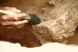 |
| The oldest center of Dakhleh is the city of Mut, where artifacts date from Roman times, above, back to pharaonic times, lower. |
With communications with the peoples of the Nile Valley already established, McDonald theorizes, the Bashendi would have migrated there, bringing with them their domesticated cattle and distinctive technologies and artifacts.
The same climate change also dramatically altered the flow and regular flooding of the Nile itself, changing and most likely stressing the relatively comfortable lives of the Nile-side dwellers described by Hoffman’s Hieronkopolis excavations. Traditional hunting and fishing would no longer support them—particularly with the added stress of the influx of new Bashendi peoples from the west. Together with other cultures from the east of the river, an unprecedented pooling and melding of cultures began to take place that would give rise to the Predynastic cultures.
While the rise of the Egyptian state can’t be traced to a single point of origin, the presence of a large number of people in one area and attempts at coping with fluctuations in food resources often leads to the emergence of strong chiefs, notes Fekri Hassan, Petrie Professor of Archaeology at University College London. Further enlargement of both agricultural and animal production then progresses to a hierarchy of chiefs, and from that, he continues, to the first political units. Skirmishes with nearby Libyans and Asiatics would have led to a reason for people to give the chiefs military power, and for the growth of iconography to underscore a system of dominance. Hassan believes that about 500 years passed between the arrival of the Bashendi and the first emergence of chiefs. “Their mystique was sustained by the obscurity of government as it became more distant from the people and by potent religious and power symbols,” he writes. Along with control of agricultural production, he theorizes, it “set the stage for the political transformation of a society that culminated in the rise of kings and pharaohs.”
Most archeologists now agree that the Neolithic Revolution of the Nile Valley was homegrown, with important, even decisive inputs from the Western Desert, and that it grew in complexity to become the Old and New Kingdoms. “Mary’s work has been an outstanding contribution to our understanding of the origins of Egyptian civilization,” says Hassan, who was among her early supporters. “Her work confirmed that one of the main strands in the early civilization of the Nile Valley was the contribution from the inhabitants of the Sahara.”
 |
| Although Dakhleh is today one of Egypt’s most modern agricultural regions, around its older parts, animal-drawn carts are still used, harking back to the first domestications of animals more than six millennia ago. |
According to discoveries so far, it was another 1500 years before the civilization that grew out of the Neolithic Revolution on the Nile would make significant ventures back west to Dakhleh again. Not too far from where we stand, a rock inscription was found a few years ago by a German expedition. It tells of a mission dispatched by Cheops and his son to search for minerals for the kingdom.
Reports must have come back positive. Dakhleh looked promising enough to justify the establishment of a permanent Old Kingdom settlement there. Mills and his wife, Lesley, also an archeologist, are now excavating a Fifth Dynasty site nearby at Ain el-Gazzareen that dates to about 2300 bc, and which is thought to be the oldest in the region. “Long-distance traffic was going on long before then,” says Mills. He thinks Ain el-Gazzareen was likely the westernmost settlement of the Dynastic period, and that it may have served as a Pharaonic “last outpost” before trading caravans headed west and north to places like Libya. Mills has found ample evidence of a large bread-making industry—thousands of broken bread molds, as well as huge quantities of animal bone. Along with water, bread and dried meat would have provisioned any convoy.
That would have been critical in such unforgiving terrain. Sand in our eyes, we take one last look around before returning to our Land Rover, well pleased with having trodden in the earliest footsteps of what would become perhaps the world’s most captivating civilization.
 |
 t was on January 20, 1988, while excavating a third- century Roman house at Kellis, part of the Dakhleh Oasis Project, that student volunteer Jessica Hallet excitedly called out to her supervisor to come and look at a piece of wood with writing on it. Colin Hope, director of the Centre for Archaeology and Ancient History at Australia’s Monash University, wandered over to delicately brush sand from it. What emerged from that ancient kitchen were two wooden-paged books. One contained three speeches by the Greek orator Isocrates; however, it was the other book, underneath that one, that has garnered more attention. t was on January 20, 1988, while excavating a third- century Roman house at Kellis, part of the Dakhleh Oasis Project, that student volunteer Jessica Hallet excitedly called out to her supervisor to come and look at a piece of wood with writing on it. Colin Hope, director of the Centre for Archaeology and Ancient History at Australia’s Monash University, wandered over to delicately brush sand from it. What emerged from that ancient kitchen were two wooden-paged books. One contained three speeches by the Greek orator Isocrates; however, it was the other book, underneath that one, that has garnered more attention.
The second book, dubbed the Kellis Agricultural Account Book, is a revealing record written by the manager of an agricultural estate of all the comings and goings of the business of the estate over three years. Its 1784 entries list payables and receivables, including annual obligations to the landlord, the mistress of the house and the field workers. Income items include crops like wheat, barley, chickens, figs, olive oil, honey and wine. Outgoing payments included “to Syrion, for wage,” “to Father Psennouphis, for wedding gifts,” “transport charge,” and notes indicated how each payment was made, whether in cash or produce or both. It’s an extremely important written record that can be compared to archeological remains found at the site.
The three years of the Kellis book were either 361 to 364 or 376 to 379, just before the site was abandoned. Wooden books were popular at the time, though papyrus ones were about to come into common use. A private letter, written in Greek and found in the house next door, contained an order: “Send a well-proportioned and nicely executed 10-page notebook for your brother Ision.” The addressee didn’t have to go far. A room adjacent to where the book was found revealed a bookmaker’s workshop containing acacia-wood mallets, three cut wooden pages, a block marked for cutting and a tool box which allowed Hope to reconstruct the process of making the book.
Hope agrees that calling it “the world’s oldest book” is a matter of definition. “It’s certainly the oldest as we know a book,” he says, “with a front and back cover, a pagination system and individual pages bound at the spine.”
Made from a single block of acacia wood, the book’s eight pages measure 33 by 11 centimeters (13"by 4"). Each page is coated with gum arabic to provide a writing surface. They’re held together by tightly spun linen strings threaded through pairs of holes drilled at the top and bottom. Should the binding ever have broken, re-ordering the pages would have presented no problem: Notches along the spine line up to a perfect V when the pages are in the correct order.
The book is now safely housed in the Kharga Archeological Museum in Egypt’s Kharga Oasis, near Dakhleh, where crops similar to the ones named in it are grown, and similar payments continue to be made. |
 |
Archeologist and free-lance writer Graham Chandler lives in Calgary. He can be reached at grahamchandler@shaw.ca. |
 |
Michael Nelson (masrmike@gmail.com) is the Middle East regional photo manager for the European Pressphoto Agency (EPA) in Cairo. Dr. Mary McDonald’s research at the Dakhleh Oasis Project has been supported in part by the National Geographic Society.
|