It is India’s largest island, yet most of the year it’s connected to the mainland on its northern and eastern sides by wide salt pans called ranns—a term derived from the Sanskrit word for “waste.” During monsoon season, roughly from July to October, the ranns are often flooded, waist deep in places.
 |
| Click above for a video exploring Kutch. |
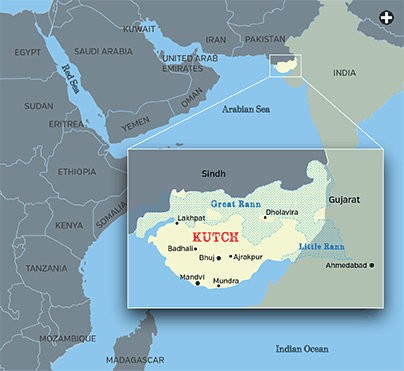
 or a year after India’s independence in 1947, Kutch, now a district of the state of Gujarat, kept its own currency, the kori; its own sovereign, the maharao; and its own time zone, a half-hour earlier than Delhi, India’s capital. It takes its name from the local word for tortoise, katchhua, and it does resemble a tortoise floating upside down in the Arabian Sea. It is the sea, which links it more closely to East African and Arabian ports than overland routes have ever tied it to India’s hinterlands, that best defines Kutch’s history.
|
|
The videos in the above Google map are best viewed
in Internet Explorer, Chrome or Safari browsers. Automatic links following this video may present content unrelated to Saudi Aramco World, and such content is neither placed nor endorsed by Saudi Aramco World or its publisher. |
Though Kutch has been increasingly integrated into Gujarat for the past 60 years, it is still something of a place apart, not least for the unique geology that makes it an active earthquake zone in the ongoing slow-motion smash-up of the Indian and Eurasian tectonic plates. From yet another angle, it can be viewed as a cultural parallel to the theory of island biodiversity, which posits unique evolutionary paths for the flora and fauna of isolated areas. For Kutch, this distinctiveness is most clearly expressed in the differently embroidered and dyed dress styles of its ethnic groups—Rabaris, Ahirs, Jats and others—each as unique as the gaudy plumage of different birds of paradise.
L. F. Rushbrook Williams, author of The Black Hills: Kutch in History and Legend, called Kutch a “strange, semi-island country” that presents “an epitome of the larger story of India—constant invasions, a fusion of cultures ... with a remarkable wealth of remembered history, little of which has been written down.” The 1880 edition of the Gazetteer of the Bombay Presidency, a handbook for the British Raj, noted that the “national character” of Kutch was more distinct than any of the government’s other dependencies.
 |
This regional separation is personified in the lives of two legendary men from the 18th century who are still highly venerated today, and who were once regarded as the protectors of travelers venturing to and away from Kutch. Mekaran Dada, along with his dog, Motia, and his donkey, Lalia, was said to rescue those stranded in the Great Rann’s salt flats, much as Swiss monks and their dogs rescued snowbound travelers in the Great St. Bernard Pass in days gone by. Farther to the south and facing seaward, Murad Shah al-Bokhari, who came to Kutch from landlocked Central Asia and is buried in the port of Mundra, was said to protect sailors setting out across the Arabian Sea.
To arrive in Kutch from eastern Gujarat, one must cross a bridge over the Little Rann at the head of the Gulf of Kutch, home to the khur, or wild Indian ass (Equus hemionus khur). The khur’s cousins include related subspecies in Mongolia, Turkmenistan, Persia and Tibet—some on the endangered species list published by the International Union for the Conservation of Nature. About 4000 khurs live in and around the 5000-square-kilometer (1930 sq mi) Wild Ass Sanctuary in the Little Rann.
The Moghul emperor Jahangir (1569–1627) wrote in his memoirs about hunting and eating wild asses that “most people eat it with relish, but it is repugnant to my nature.” A 19th-century Englishwoman said she could lasso a khur foal but never fully tame one, and because of this doubted Herodotus’s account that the Indians had trained them to pull chariots. Today the animals are so approachable that hunting them would be quite unsporting.
 ften within sight of the khur are 40,000 salt workers who come to the Little Rann in the fall months, after the monsoon’s flood has dried, to pump groundwater into hand-dug evaporation pans. The harsh sun dries the saline water, finally resulting in salt crystals—a staple made famous around the world by Mohandas Gandhi’s march to the sea from Gujarat’s capital, Ahmedabad, in 1930 to protest Britain’s monopolistic salt tax. Because the Little Rann produces almost half of India’s salt, it is fair to say that something of Kutch and its nearby districts is on every Indian table.
 |
Dotted throughout the Little Rann and Great Rann are the bets, inhabited islands rising above the salt-pan floors. They are just “offshore” from what might be called “mainland Kutch,” at whose center is the town of Bhuj, chosen by the ruling family as their seat of power in 1549. In Bhuj’s walled city center is the royal precinct, placed on the World Monuments Fund’s endangered-sites list after an earthquake measuring 7.9 devastated the area in 2001.
Here is the 18th-century Aina Mahal, or Palace of Mirrors, its central room encrusted floor to ceiling with reflective glass, gilded stucco and Delft tiles. The tiles are a tribute to Holland by Ramsingh Malam, a local sailor saved from shipwreck off the African coast by a homeward-bound Dutch vessel. In Holland, he learned the European decorative arts before returning to Kutch as the maharao’s personal architect.
One of the room’s highlights is an ivory-inlaid door, which some years ago the Victoria and Albert Museum asked to borrow for an exhibition in London. On display beside it is a letter from the maharao’s secretary declining the request, citing the significance of his family’s long uninterrupted rule. “As you know,” the letter explains, “our dynasty dates back to the founding of the House of Tudor,”an arch reminder that Kutch’s royal line stretches back more than 400 years, further than that of Henry viii, and is still counting.
Maharao Pragmalji iii, 77 years old and ramrod straight, is the 19th in that line. His title is now strictly honorific, the family’s sovereignty having been surrendered when Kutch joined the Indian Union in 1948. Yet he still wields moral authority.
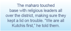
During religious riots in 2002 that tore eastern Gujarat apart, he made sure that Kutch remained calm. “I am not much for using the telephone,” he says, speaking in his palace garden, “but in one day I made more calls than I’ve ever made in my life, touching base with religious leaders all over the district, making sure they kept a lid on trouble. I told them we are all Kutchis first.
“Sindh [in Pakistan] is closer to us by sea than [the Gujarati capital of] Ahmedabad is by land,” he continues. “Arabia was always our best trading partner, because our sailors could catch every breath of wind to get there.” Nonetheless, the maharao has high praise for two modes of land travel—a local breed of horse, its bloodline now sadly lost, similar to the famed “Kattywar” cross of Arabians and Indian ponies, and, more surprisingly perhaps, imported American cars. Snapshots of the maharao on horseback and behind the wheels of his beloved Corvettes and Studebakers hang on the palace walls.
 utch is firmly on the Indian textile tourism trail these days, and much credit for that goes to the Shrujan Foundation, named for the Sanskrit word meaning “creativity.” Chanda Shroff founded Shrujan in 1968 amid a long drought in the region, during which women in a village she knew were forced to sell off their finely embroidered clothes to put food on the table.
“These women were desperate,” says Shroff, winner of the 2006 Rolex Award for Enterprise in cultural heritage. “They had already sold off their jewelry and even their animals. Their prized embroidery was the last to go.”
She helped them sell their family pieces at good prices in Mumbai, but decided it would be better to assist them to produce directly for the market. Now working in 120 villages, Shrujan promotes textiles as a steady source of income for women, organizing production teams around a “pattern library” of 1000 embroidered panels. Each panel represents a different technique, ethnic design or material, and the panels are used as teaching tools when the foundation’s bus visits villages where such fine handiwork might otherwise be forgotten.
ne local textile tradition strictly in the domain of men is ajrakh, a block-printed and resist-dyed cloth used for shawls and turbans. The word comes from the Arabic for blue, azraq, after its primarily indigo hues. Dr. Ismail Mohmed Khatri, who holds an honorary doctorate of arts from England’s De Montfort University, counts back 11 generations to the year 1634, when his family came from Sindh at the invitation of the third maharao, who wanted to promote local crafts. He gave the family its choice of lands with the best quality groundwater, cloth-dyeing being an especially thirsty endeavor with a low tolerance for impurities.
After the 2001 earthquake increased the amount of dissolved iron in the well water, the family relocated to a place aptly named Ajrakhpur. A visitor to the family compound can see some of the 20-odd individual steps in producing the cloth—from double-sided printing with wooden blocks and pre-soaking the cloth in a mix of camel dung, soda ash and castor oil, to mixing the dye-resistant pastes from gum and millet flour and blending secondary dyes from an array of natural sources: yellow from turmeric, brown from rhubarb, orange from pomegranate skin, red from madder root and black from a boiled syrup of scrap iron, chickpea flour and sugar-cane molasses.
Small fragments of Kutch-made ajrakh more than 500 years old have been found at Fustat, Cairo’s first Islamic settlement; the largest collection, some 1200 scraps, is at the Ashmolean Museum in Oxford, England. Curators there think that the many tailoring and mending seams in the pieces indicate that ajrakh was a utilitarian garment cloth rather than a luxury good, and that it was desirable in Egypt because of the high quality of its colorfast dyes and the intricacy of its designs.
The fragments came to light early in the 20th century, offered for sale by Egyptian antiquities dealers. The scraps were identified as of Indian origin when their designs were compared to similar motifs from the ancient Indus Valley sites of Harappa and Mohenjo-Daro and from Kutch’s own Dholavira. Many designs appeared to have been made specifically for the Middle East trade, such as a circular pattern called the riyal by Kutchi dyers, after the Arab coin.
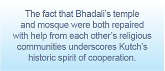
The earthquake that prompted the Ismail Khatri family’s move to Ajrakhpur devastated wide swaths of the district, killing some 20,000 people. Bhadali village, with a population of 1200 Hindus, Muslims and Jains, was hit particularly hard: 85 percent of its 325 houses were flattened. But under the direction of a Mumbai architectural team, the villagers helped to design three types of modular homes that they could construct economically.
n a recent tour, town elders Umar Farouk, head of a textile-dyeing family, and Lavji Lakamshah, a Jain, were accompanied by council president Jyotiben Gouswami, a female priest at the local Hindu temple. A visitor was curious to know why their village was nominated for an Aga Khan Award for Architecture and received honorable mentions from the International Union of Architects and the Social Economic Environmental Design Network, which sponsors projects worldwide.
“We had not one squabble over access to funds or materials,” says Gouswami. “We always worked side-by-side here, neighbor helping neighbor, so our village was rebuilt before any others nearby.” The fact that Bhadali’s temple and mosque were each repaired with help from the other’s religious community underscores this spirit of cooperation.
A Kutchi town hard-hit by an earlier earthquake, this one in 1819, was Lakhpat, a fort site on the Kori Creek’s tidal flat facing the Pakistan border. The tremor was named the Allah Bund, or “Dam of God,” after a 100-kilometer-long (66-mi), six-meter-high (20') wall of sand and clay it threw up along the fault. In Ahmedabad, nearly 500 kilometers (300 mi) distant, the quake toppled the main mosque’s minarets and gave the so-called shaking minarets of the Sidi Bashir mosque, situated just behind the railroad station, a harder rattling than the loudest train whistle ever did.
 |
Lakhpat was once an important tax-collection port for Kutch’s sea trade. The 1819 earthquake blocked the port, however, and caused the population within its walls to dwindle to today’s paltry few resident fishermen, among them 22-year-old Rajjak Nur Muhammad, at home nursing a stingray wound in his foot. A group of Sikh pilgrims is here, too, visiting to honor their religion’s founder, Guru Nanak (1469–1539), who is said to have rested in Lakhpat en route to Makkah.
Soldiers from India’s Border Security Force climb Lakhpat Fort’s creek-side towers daily to scan the northern horizon, and weekly they make the difficult trip by boat and on foot across the flats to sign the register at the Pakistan boundary post 35 kilometers (22 mi) away. At the fort’s main gateway on the opposite side, however, an old wooden door studded with sharp iron bosses lies askew: Apparently the Indian military has no fear of invasion by land.
A Kutchi legend holds that the world is built upon the head of a snake whose tail is not firmly nailed down, so its constant writhing produces tremors in the earth. Professor M. G. Thakkar, the foremost expert on Kutch’s seismology, does not subscribe to that theory, of course, but recently a fuzzy shape on a satellite photo of the area did catch his attention. A field trip to its location on a mudflat revealed the outline of a long-forgotten five-sided fort that had been nearly swallowed by the Allah Bund earthquake, as if that mythical snake had regurgitated its meal.
Thakkar is intrigued by yet another buried legend: the exact location of the Saraswati, a semi-mythical river that flowed from the Himalayas, according to passing references in ancient Indian texts. The Saraswati is thought to have followed the bed of the Ghaggar River in its upper course, but, in the words of the Mahabharata, it then “disappeared and reappeared” several times—as monsoonal-flow rivers are prone to do—before “jumping into the sea” somewhere in the Great Rann. Thakkar would like to find evidence of the river’s high-mountain origin, such as a continuous line of alluvium rich in mica sand in the underground strata.
 t is quite likely that Alexander the Great set foot not far from Lakhpat in 325 bce, when his chronicler Arrian says he descended the easternmost branch of the Indus in search of access to the sea to send his fleet home under the admiral Nearchus. Arrian wrote of this Indus branch forming a lake just before it reached the sea, “spreading wide over a flat country,” which sounds much like the Great Rann when it floods.
Strabo the geographer quoted Onesicritus, one of Alexander’s helmsmen, as saying that the coast here “abounded in swamps, particularly at the mouths of the river, owing to the mud, the tides, and the want of land breezes.” British writer Michael Wood visited Lakhpat 10 years ago to research his book In the Footsteps of Alexander the Great, choosing to come ashore there because it is the first place downstream that is underlain by rock, not mud, thus providing a dry landing.
Onesicritus, meet Baba Malam, an 83-year-old navigator and ship captain far more widely traveled in the Arabian Sea than any Greek in Alexander’s navy, and now a pensioner in the port town of Mandvi, not far east along the coast from Lakhpat. Baba is an honorific title, while malam comes from the Arabic word mu‘allim, meaning “teacher” or “one learned in a trade,” and understood here as “master of the sea.”
Baba Malam’s 60 years of experience—as often sailing to South India, the Maldives and Sri Lanka as to ports in East Africa and the Arabian Peninsula—were fraught with danger. His father drowned in a typhoon off Mangalore in 1964. A storm on May 20, 1963 struck Salalah, Oman, on the Indian Ocean, while he was ashore, swamping his ship and drowning 12 of his crew. The exact dates of such storms, at least in the minds of Kutchi sailors, are as firmly remembered as the dates of earthquakes are in the minds of Kutchi villagers.
Today, with his carefully folded harbor charts to Karachi, Colombo and Goa, alongside a well-oiled Kelvin and Wilfrid White Co. sextant and a much thumbed edition of Norie’s Nautical Tables, Baba Malam is still ready to ship out at a moment’s notice.
 he words of Mandvi historian Manubhai Pandhi, “Our culture is wet with the sea,” seem most apt when standing at the town’s dhow-lined creek as the tide flows in. The Englishwoman Marianna Postans came ashore at Mandvi in 1830. In her book Cutch: Or, Random Sketches, based on several years of residence, she wrote that the local mariners were a “most fearless and enterprising race” and that “the malams were singularly intelligent and well informed.”
All about are boatyards with new ships being built and old ships under repair, skeletal hulks waiting to be broken up for parts and some simply abandoned at the water’s edge. The sounds of hammers and drills fill the air, as do the heady fragrances of mutton tallow and groundnut oils, used as preservatives, and freshly sawn, hardwood ship lumber—Burmese teak for decking, Malaysian sal for below-waterline planking and naturally bent Kutchi babool (acacia) for the curved ribs.
The iconic sailing vessel of the Arabian Sea, the transom-stern oceangoing dhow, has been replaced here by speedier boats with V-shaped hulls, built in the style of those from the south Indian port of Tuticorin. But even their construction relies on the skills of traditional Gujarati artisans, in the form of handmade iron nails from Rajkot and cotton sails sewn in Porbandar, the seaside birthplace of Mohandas Gandhi.
An even wider array of hull designs can be seen in the miniature fleet of 86-year-old model-shipbuilder Shivji Budah Fofini. His workshop sign identifies him as “Ex-gunner of Mandvi port,” but he tells stories of an earlier life from the age of eight, visiting harbors from East Africa’s Beira, Zanzibar, Lamu and Mogadishu, to the nearer Baluchi ports of Gwadar, Pasni and Ras Ormara, with Abu Dhabi, Bandar Abbas and Basra in the Arabian Gulf in between.
Fofini’s models include local machvo fishing skiffs, Indus River creek boats called hourros and that workhorse of Kutchi cargo ships, the vahan. “It was nearly always 42 days outbound, around the time of the Hindu Holi festival, carrying mostly Malabar coir [coconut fiber], and 32 days inbound at the time of the Diwali festival, carrying mostly Zanzibari cloves,” he remembers, his mind stirred by the thought that this year’s Diwali is soon to start.
Cargoes in earlier centuries were far more varied. As historian Rushbrook Williams put it in one of the more exotic shopping lists ever written, “Mandvi argosies brought bullion, grain, timber, rhinoceros hides, cardamons, pepper, ginger, silks, and drugs from Malabar, Mocha, Muscat, and the African coast, taking in return the cotton, cloth, sugar, oil, butter, and alum of Kutch and its hinterland.” Local handiwork made from that rhino hide can still be seen in the Kutch Museum’s collection of royal shields, some studded with semiprecious stones.
With a slowdown in business from cargo carriers, shipwright Ibrahim Mistry has recently taken on a new kind of client: eccentric sea-loving owners of luxury craft built to exacting, hand-hewn standards. Not long ago, his boatyard completed a transom-stern, two-masted sailing dhow with carved fittings for an American who wanted to sail the Arabian Sea in the most historically correct manner possible in this century.
Mistry will soon be undertaking a big job for an expatriate Gujarati—a 33.5-meter (110'), three-masted schooner fitted with 10 sails, designed by a top American marine architect who personally chose him as his builder. “My great-grandfather was a simple farmer who came to work in the yards here, making dhows for the Zanzibar trade,” says Mistry, unrolling the new boat’s computer-generated blueprints. “What would he say if he could see me now, building passenger schooners and dhows for wealthy foreigners? Not much has changed in all these years. After all, Kutch does face the sea.”
 |
Louis Werner (wernerworks@msn.com) is a writer and filmmaker living in New York. |
 |
David H. Wells (www.davidhwells.com) is a freelance documentary photographer affiliated with Aurora Photos. He specializes in intercultural communications and the use of light and shadow in visual narrative. A frequent teacher of photography workshops, he publishes the photography forum The Wells Point at www.thewellspoint.com. |