
 he Greeks were separated from India by the powerful Persian Empire, and it was via Persia that knowledge of India and southern Arabia first percolated to Greece. Even before the conquests of Alexander, who died in 323 BC, Greeks had served the Persian emperors as mercenaries and officials, and it was from them that Herodotus, writing in the fifth century BC, learned something of what lay to the east.
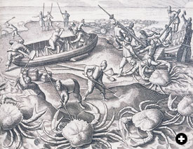 |
| Like the giant gold-digging ants Herodotus described in the fifth century BC or this 16th-century depiction of shipwrecked Portuguese sailors battling giant crabs in the Indian Ocean, the fantastic, the strange and the astonishing have always been ascribed to whatever lands were little-known and distant. For Europeans, this was the East. CAMBRIDGE UNIVERSITY LIBRARY (BRY, INDIA ORIENTALIS, IV, 1601) |
The first thing Herodotus mentions about India is gold. In a discussion of Darius’s revenues from 19 tributary nations, Herodotus says that the largest amount was paid by India: “The Indians, the most populous nation in the known world, paid the largest sum: 360 talents of gold.” The fact that it is improbable that the Indians paid Darius any tribute at all does not detract from the significance of the account: It shows that, by the time of Herodotus, India was already regarded as the richest and most populous place in the world—and that it produced gold. The idea of the fabled “riches of the east,” so to obsess Europeans, had already reached its classical formulation some 2500 years ago.
Herodotus tells us exactly how the Indians got the gold to pay tribute to Darius:
Eastward of India lies a desert of sand…. There is found in this desert a kind of ant of great size—bigger than a fox, though not so big as a dog…. These creatures as they burrow underground throw up the sand in heaps, just as our own ants throw up the earth…. The sand has a rich content of gold, and this is what the Indians are after when they make their expeditions into the desert…. When the Indians reach the place where the gold is, they fill the bags they have brought with them with sand and start for home again as fast as they can go; for if the ants—if we can believe the Persians’ story—smell them, they at once give chase.
The association of ants with gold almost certainly stems from the Sanskrit word pipilika, “ant gold,” which occurs in the Hindu epic the Mahabharata. Herodotus’s story may well have been generated by this metaphorical Indian term for gold dust. It caught the imagination of a number of classical authors, and the association of giant ants with gold became a standard topos of medieval literature: Whenever India and other eastern lands are mentioned, giant ants are summoned forth. Sir John Mandeville, that engaging liar of the late 14th century, placed giant gold-digging ants on the “Island of Gold” (Sumatra) in the Indian Ocean. Buzurgh ibn Shahriyar, author of the 10th-century ‘Aja’ib al-Hind (Wonders of India), gives a rationalizing version in which the ants infest the gold-bearing sand, but it is men who mine it, “digging tunnels like ants; out of the tunnels come swarms of ants the size of cats and eat the men and tear them to pieces.”
The Mariners of Southern Arabia
In ancient times, the peoples of South Arabia were the paramount mariners in the Indian Ocean. Their function in the economy of this huge area was in some ways comparable to that of the Phoenicians and Carthaginians in the Mediterranean. But there were also great differences: For one, South Arabia was itself a producer of valuable gums and aromatics, particularly frankincense and myrrh, much sought after for religious purposes by all the empires of the time. South Arabia, in particular Yemen, also had a flourishing agriculture based on sophisticated techniques of water management. This was because Yemen just catches the edge of the monsoon, giving it a higher rainfall than the rest of the Arabian Peninsula and permitting intensive agriculture and the growth of centralized states. Yemen was also a key area in the transmission of food plants between India and Africa. From the middle of the first millennium BC, South Arabians dominated the carrying trade in the western Indian Ocean, a position they held until modern times. This kind of historical continuity is rare and is one of the most astonishing things in the history of the Indian Ocean. |
Buzurgh ibn Shahriyar locates his ants not in India, but in “the land of Zanj”—East Africa. Confusion between India and East Africa persisted even after Alexander’s expedition to the Indus and the exploration by his admirals of the Arabian coasts. Alexander had found elephants and crocodiles in India; similar animals were found in Africa. Surely this was evidence that the two were somehow connected! Such speculations reached their extreme with the idea that the Ganges flowed into the Nile.
If we can believe Herodotus, the Egyptians discovered the true shape of Africa and the sea route to Europe more than 2000 years before the Portuguese. Pharaoh Necho, who came to the throne in 609 BC, undertook two projects of astonishing originality. He constructed a canal linking the Nile to the Red Sea—a project that claimed the lives of 120,000 workers—to facilitate trade with the incense lands of southern Arabia and the Horn of Africa. The second project may have been motivated by simple curiosity: He hired Phoenicians, the foremost mariners of the ancient world, to circumnavigate Africa. They “set out from the Red Sea and sailed the southern sea; whenever autumn, came they would put in and sow the land…and there await the harvest; then, having gathered in the crop, they sailed on, so that after two years had passed, it was in the third that they rounded the Pillars of Hercules and came to Egypt” through the Mediterranean.
There were other voyages of exploration in the sixth and fifth centuries BC. A Latin poem by Avienus, based on a much earlier Greek original, describes a voyage around 550 BC down the West African coast by a sea captain from Marseille. He reached either the Senegal River or the Gambia and identified it with the Nile, just as the Portuguese were to do 2000 years later. To the east, the Persian emperor Darius, who reigned between 521 and 486 BC, explored the Indian Ocean between the Indus River and the Red Sea.
 |
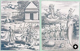
| The Andaman Islands in the Bay of Bengal were said to be inhabited by wolf-headed people, who were depicted in a “book of wonders” produced in Paris in the early 15th century. Such manuscripts, commissioned by wealthy patrons, presented tales of distant lands for the entertainment of their readers. BIBLIOTHEQUE NATIONALE / ARCHIVES CHARMET / BRIDGEMAN ART LIBRARY (BOUCICAUT MASTER) |
Six years after the death of Darius, the Carthaginians sent a huge expedition down the coast of West Africa. According to the Greek translation of a Punic text said to have been inscribed on a stele in Carthage, an admiral named Hanno set out with 60 galleys and 30,000 colonists. He founded a number of trading stations along the coast—including Agadir, which thrives today—and reached as far south as the mountain called Theon Ochema in Greek, the Chariot of the Gods—probably Mount Kakulima in Guinea.
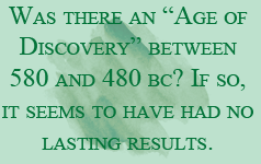
It is tempting to link these Egyptian, Persian and Carthaginian voyages of exploration, as they all took place between about 580 and 480 BC and most had a Phoenician connection. The time span of 100 years is comparable to the time it took the Portuguese to find their way around Africa. If we can credit these accounts, do they tell of an “age of discovery” in the sixth century BC?
If there was such an age, it seems to have had no lasting results. Even the authors who recorded these events, principally Herodotus and Strabo, were unknown to Europe until after the European Age of Discovery. The Greek defeat of Darius at Marathon in 490 BC put an end to his conquests in Europe, and the rise of Rome embroiled the Carthaginians in a series of debilitating wars that ended with the Roman destruction of Carthage.
 |
| Philippus Baldaeus’s 17th-century account of Ceylon and the Malabar and Coromandel coasts of India included cultural as well as geographical information. His depictions of episodes from Hindu mythology were almost certainly based on Indian originals. Baldaeus spent the years 1658 to 1665 in Ceylon, and his extensive and factual account contributed to Europeans’ understanding that eastern civilizations had literary and iconographic traditions as complex and sophisticated as those of the western world. CAMBRIDGE UNIVERSITY LIBRARY (BALDAEUS, NAAUKEURIGE BESCHRYVINGE…, 1672) |
Asian expansion to the West was not to resume for some eight centuries, until the rise of Islam in the seventh century AD.
It would seem to be a fact that the remotest parts of the world are the richest in minerals and produce the finest specimens of both animal and vegetable life. —Herodotus
That wonders, like exotic plants and rare minerals, increase with distance also became a topos of the western view of the East. The first known book devoted entirely to India is from the late fifth century BC, written by a Greek doctor named Ctesias, who served the Persian king Artaxerxes. Everything in it is hearsay, filtered through Persian sources. Fact and fancy mingle without distinction. Along with the real elephants, long-tailed monkeys and talking parrots are imaginary giant dogs, a fountain of liquid gold and tigers with human faces. The interior of India is inhabited by pygmies who hunt with birds, according to Ctesias. The mountains abound with silver and gold, guarded by griffins, four-legged birds the size of wolves. Everything in the East is bigger and better, a point also stressed by Herodotus: The sheep and goats are bigger than donkeys and the dates are three times the size of those of Babylonia. There is a magical fountain whose waters make men tell the truth—very useful to the king! Indians never have toothaches or headaches. They live to the age of 200. Dog-headed men live in the mountains; they cannot speak, but only howl. Nonetheless they have dugout canoes and trade in a purple dye better than any found in Greece.
It is only with Alexander the Great that we reach firmer, more factual, ground. His conquest of the Persian Empire brought the Greeks in 326 BC to the banks of the Indus River, at the northwestern edge of India. This expedition provided a great deal of firsthand information about the peoples, government, customs, plants and animals of India. Alexander sent his admirals to explore the coasts of both the Gulf and the Red Sea, and himself voyaged a symbolic 500 stadia into the Indian Ocean. Rumors of countries located east of India and in the Indian Ocean began to reach the West.
Taprobane and Serendipity
Strabo, who lived from 63 BC to AD 21, mentions the island of Sri Lanka under the name Taprobane, from the Sanskrit Tamraparni. He says it lies on the same parallel as the Horn of Africa and that it exports large quantities of ivory and tortoiseshell to India—but he does not mention cinnamon, which did not begin to be cultivated in Sri Lanka until much later. Strabo magnifies the size of the island by a factor of 14, an error that would not be corrected until the European voyages of the 16th century. Greek merchants from Egypt traded with the island in Strabo’s time, and numbers of Roman coins dating from the third century of our era have been found on the island. An embassy from one of the rulers of Taprobane even visited Rome. Between the third and sixth centuries, Sri Lanka became one of the major trading destinations in the Indian Ocean, particularly for merchants from Persia and the Ethiopian kingdom of Axum. Sri Lankan pearls, ivory and gemstones were famous and continued to be much sought after in Islamic times, when the island was known as Sarandib—the name from which Horace Walpole, writing in the 18th century, coined the word “serendipity.” |
The sources for Alexander’s expeditions are all late, contemporary accounts having perished. Fortunately, the geographer Strabo, who published his great compilation in 7 BC, preserved some earlier information. He is in general skeptical of the accounts of India: “All who have written about India have proved themselves, for the most part, fabricators, but preeminently so Deimachus; the next in order is Megasthenes; and then Onesicritus and Nearchus, and other such writers who begin to speak the truth, but with faltering voice.”
Megasthenes and Deimachus had both spent time in India. Megasthenes gives a fascinating description, partially preserved by Strabo, of the Mauryan court of Chandragupta in Pataliputra around 302 BC. He describes the caste system, customs such as suttee, the form of government and the flourishing state of trade, the wealthy markets and skilled artisans. What Strabo objected to was not this, but that Megasthenes also described the Enotokoitas, the men who sleep wrapped snugly in their ears; the Monophthalmous, men with one eye in the center of their forehead; the Opisdodaktulous, men with fingers that turn backwards; the lively descriptions of battles between cranes and pygmies; and the inevitable gold-mining ants. These wonders captured the popular imagination of Europe up through the Middle Ages; they can be found cavorting among the grotesques on the facades of Gothic cathedrals and in the margins of illuminated manuscripts.
Strabo describes India as “the greatest of all nations and the happiest in lot.” The Greek word for “happy” or “fortunate” is eudaimon, and it was applied both to India and to southern Arabia: Eudaimon Arabia to the Greeks and Arabia Felix to the Romans. The idea that lands to the east, where the sun rose, were happy and prosperous utopias was a third persistent topos that fired the European imagination. Somewhere toward the rising sun lay enchanted lands filled with fragrant spices, precious gems, exotic plants and animals. Because Megasthenes and others had also presented idealized portraits of rulers like Chandragupta and their kingdoms, it became a commonplace that to the east dwelled peoples with a natural sense of justice, ruled by wise laws.
It is thus no accident that the Greek writer Euhemerus located his imaginary utopia on the island of Socotra, off the coast of “Happy Arabia” in the waters of the Indian Ocean. It was on another island that Ibn Nafis, writing in the 13th century, placed his natural philosopher who deduced the principles of Islam from the observation of natural phenomena. The 16th-century Italian philosopher Tommaso Campanella located his City of the Sun on an island in the Indian Ocean, as did Sir Thomas More his Utopia.
It is not until Roman times that we begin to get a clearer picture of eastern lands. This is largely thanks to a Greek work written around AD 70 and called The Periplus of Erythraean Sea. This precious little document, almost certainly written by an Egyptian trader from Alexandria, is entirely devoid of fantasy. It lists all the ports of the Red Sea, on both the African and Arabian coasts, their exports and imports, and some details of their political and ethnic makeup. It gives information about the incense trade with South Arabia and describes the thriving commerce between Egypt, East Africa and the major ports of the western coast of India, the most important of which was Barygaza —today’s Bharuch.
 Greek trade with the peoples of the Red Sea coast and eventually with India began under the Ptolemies, the dynasty that derived its name and foundation from one of Alexander’s generals, who took power in 320 BC. His successor, Ptolemy II, extended his authority to the Red Sea for two reasons: to control maritime trade and to obtain war elephants from the African interior. (A by-product of the hunt for elephants was ivory, extremely valuable and much sought after in Mediterranean markets.) Ptolemy needed elephants—the tanks of ancient warfare—to oppose those of his rivals, the Seleucids, whose rule over much of what is now Iran, Iraq and Syria gave them control of the overland and Arabian Gulf routes to India and thus a constant supply of elephants.
The first shipment of East African elephants reached Egypt in the 260’s BC; its arrival was commemorated by an inscription on a stone stele. The trade and the hunts led to both the reopening of the silted- up canal of Necho and the founding of a chain of hunting stations and trading ports along the African coast of the Red Sea: Myos Hormos, Philotera, Berenike, Trogodytica and finally Ptolomeis of the Hunts, 80 kilometers (50 mi) south of Port Sudan, not far from Suakin. As the hunts reduced elephant populations, the expeditions were forced to venture farther and farther south.
Myos Hormos, “Mussel Harbor,” was the major Red Sea port during Ptolemaic times. Its site has now been identified with al-Qusayr, on the Red Sea coast of Egypt. Strabo says it was visited by an average of 120 ships a year on the India run. Berenike was linked by road with Coptos on the Nile, just north of the gold mines of Wadi al-‘Allaqi. At Berenike, archeologists have discovered fragments of documents in 12 different languages, including Tamil and Prakrit, evidence that this Red Sea port was in touch with both southern and northern India.
Ptolemy II ’s drive down the African coast and into the Red Sea led his navigators to the western edge of the monsoon system, and it was only a matter of time before the Greeks discovered its secrets, long known to Arab and Indian sailors.
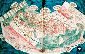 |
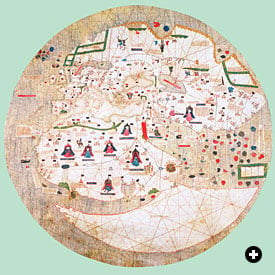
| Above: A map of the world based on a description by Claudius Ptolemaeus of Alexandria (Ptolemy), who lived in the early second century of our era. The Arabian Peninsula and the Red Sea lie just left of center. Note how the east coast of Africa curves eastward to connect, at far right, with China, thus making the Indian Ocean an enclosed sea. Below: The map of al-Idrisi dates from 1154, and is oriented with south at the top. Note how the east coast of Africa in this map also turns east but does not connect with China; rather, it opens into the “All-Encompassing Ocean.” Thus in the Ptolemaic view, circumnavigation of Africa is impossible, while in al-Idrisi’s view it is technically possible, though too daunting to undertake. UPPER: BRITISH LIBRARY / BRIDGEMAN ART LIBRARY; LOWER: BODLEIAN LIBRARY |
 |
The Periplus of the Erythraean Sea attributes this discovery to a merchant named Hippalos and gives the date as 125 BC, but there are Greek references to the monsoon system before Hippalos. The Greek practice of ascribing “firsts” to named individuals—a habit they bequeathed to Muslim authors—must therefore not be taken too seriously. Nevertheless, Hippalos may have inaugurated actual sailing with the monsoon, thereby making regular trade with India economically viable and for the first time linking the Mediterranean trading world to the Indian Ocean. By the first century of our era, Greek and Roman merchants were trading with India as a matter of course, as confirmed by finds of Roman coins and pottery at Indian sites.
By that time, too, trade with southern Arabia, India and China—the three key exporters in a complex network—appeared as a growing threat to the Roman economy. The gold and silver of the empire was draining to the east to pay for unnecessary luxuries. “And by the lowest reckoning India, China and the Arabian Peninsula take from our empire 100 million sesterces every year—that is the sum which our luxuries and our women cost us,” wrote Pliny in a famous passage. He returns again and again to the theme. It became a commonplace in the literature of the time to contrast the “manly” austerity of the past with the “effeminate” luxury of the present, to view Rome as emasculated by spices, aromatics, perfumes, Indian muslins and Chinese silk. In fact, 100 million sesterces was not a particularly large sum: Pliny’s nephew, Pliny the Younger, left more than three million sesterces in his will, and he was not considered particularly wealthy.
The picture we get from The Periplus of the Erythraean Sea is quite different. The trade was more complex than the simple exchange of precious metals for luxury goods. The cloth factories of Arsinoë in Egypt were manufacturing textiles aimed at specific markets, such as the kingdom of the Greek-speaking ruler Zoskales on the African coast near present-day Massawa. Zoskales imported Arsinoë robes in exchange for ivory, tortoiseshell and rhinoceros horn. Merchants from Egypt also brought him glassware, copper alloy, iron, tools, swords, bronze drinking cups and even Italian wine, shipped in amphorae. The same ruler also imported textiles, iron and steel from India. Almost no money changed hands, only a little being imported “for the use of foreigners.”
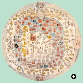 |
| A Korean world map, above, of a type whose religious and cosmological content goes back to mid–fourth-century China, is centered on the legendary Mount Meru in Central Asia. The mid–15th-century Catalan map below is similarly centered on Jerusalem, but includes reasonably accurate information on the African coast and interior as far south as knowledge of the period reached. Southward of that, the cartographer did his best to harmonize scanty fact and plausible geographical theory. UPPER: BRITISH LIBRARY (MAPS.C.27.F.14); LOWER: BIBLIOTECA ESTENSE / SCALA / ART RESOURCE |
 |
It was different in India. At Barygaza, on the Gulf of Cambay, gold and silver coins were in demand and could be exchanged advantageously for the local currency, just as they could be in Portuguese times and later. Greek traders sold or exchanged Italian and Greek wine, copper, tin, lead, coral, cloth, glass, storax and antimony for ivory, bdellium gum, onyx, myrrh, woven and unwoven silk, “mallow cloth” and pepper.
Barygaza was linked by overland trade routes to China, which only began to emerge from fable about the time of the Periplus, the last chapters of which deal with this remote economic power: “Beyond [India], now under the very north, …there lies a very great inland city called Thina, from which raw silk and silk yarn and [Chinese] cloth are brought overland to Barygaza through the Bactrians…. This Thina is not easy to reach. People seldom come from it, and not many go there….”
So Greek knowledge of the East in the first century ended at India and Ceylon, only rumor lying beyond. In the same century the Alexandrian geographer Ptolemy scattered 22,000 islands— surprisingly close to the true number—in Prasodes Thalassa, or “the Leek-Green Sea,” as he called the Indian Ocean. He told of the Golden Khersonese (Sumatra) and the Isle of Silver and placed the mysterious cities of Cattigara and Thina on the eastern rim of the world.
It would be left to the Arabs of Muslim times to explore this vast region of ocean, with its archipelagos reaching into the Pacific, to open the direct sea route to the port cities of southern China and to establish themselves as the intermediaries in the maritime trade between the Far East and the West.
The Question of Madagascar
Malagasy is the language of Madagascar, the large island just off the east coast of southern Africa. It is an Austronesian language most closely related to the one spoken by the Ma’anyan people along the Barito River in South Borneo. Who brought that language more than 7000 kilometers (4500 mi) across the Indian Ocean? And when?
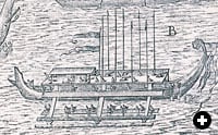 |
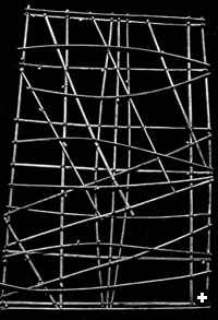
| Above: A large outrigger prahu, an Indonesian craft of a type that may have been used to cross the southern Indian Ocean to Madagascar. Below: A Micronesian rebbelib stick chart used to teach and record patterns of ocean swells for use in open ocean navigation; the shells indicate islands. UPPER: CAMBRIDGE UNIVERSITY LIBRARY (BRY, INDIA ORIENTALIS, IV, 1601); LOWER: BRITISH MUSEUM |
 |
Madagascar also shares such Indonesian cultural traits as outrigger canoes, blowpipes, wet and dry rice cultivation, houses built on stilts and the use of domesticated cattle for plowing. It is generally agreed that the island was settled by migrants who came by sea from somewhere in the Indonesian archipelago. J. Innes Miller, in his classic work on the Roman spice trade, thought Madagascar must have been settled as early as the second millennium BC, and he theorized that the cinnamon of the classical world was brought to markets in the Horn of Africa and Arabia through Madagascar from India and even China. This exciting theory, which neatly explains both the presence of an Austronesian language in Madagascar and cinnamon in the Red Sea markets, is almost certainly wrong.
The earliest archeological evidence for the presence of people of Indonesian origin in Madagascar dates from the fourth century after Christ. This would mean that, well into historical times, a major sea migration between island Southeast Asia and Africa occurred. There are echoes of such a migration in Arabic sources. Ibn Shahriyar’s Wonders of India mentions an attack on the East African coast by merchants and traders from the mysterious island of Waqwaq in 945. Al-Idrisi, writing in 1154, mentions that, in earlier times, direct voyages had been made between Madagascar and parts of Indonesia and Malaysia. In 1229, Ibn al-Mujawir mentions an attack on Aden itself by men in outriggers from Madagascar.
The settling of Madagascar by people from the Indonesian archipelago is remark-able; it should be borne in mind, however, that the Polynesians, also speaking Aus-tronesian tongues, were at the same time engaged in their epic voyages east into the deep Pacific, voyages that ended with the settlement of Hawaii around AD 400. The “discovery” of Madagascar, like the “discovery” of the Pacific islands, went unchronicled, yet both rank as extraordinary human achievements. |
Cinnamon Country
By the time of Strabo, there was another constant in classical descriptions of the Indian Ocean world: a cinnamon-producing country in East Africa. Ptolemy and The Periplus of the Erythraean Sea also speak of cinnamon and its close relation, cassia, being obtained from this area, which corresponds to modern Somalia and Eritrea. Strabo says both spices grew in the marshes formed by the Nile in what is now Sudan, where they were guarded by vicious giant bats. Cinnamon and cassia come from trees of the same family. In antiquity cinnamon grew wild in India, while cassia came from a tree that grows in Southeast Asia. Today the cinnamon gardens of Sri Lanka are the main suppliers of that spice; almost all of what is sold in the United States as “cinnamon” is in fact cassia, which is preferred there for its stronger flavor. Sri Lanka did not begin to export cinnamon until the later Middle Ages.
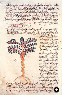 |
| An illustration and description of a Cinnamomum tree in a 10th-century Arabic manuscript of Dioscorides’ De Materia Medica. Dioscorides wrote that cinnamon was useful in combating a number of illnesses, from coughs to kidney diseases. STATE UNIVERSITY LIBRARY, LEIDEN / WERNER FORMAN / ART RESOURCE |
Modern botanists are unanimous in agreeing that cinnamon and cassia have never grown anywhere in Africa. The classical sources are just as unanimous that they did. An exception is Pliny, who in a famous passage of his Natural History says that cinnamon and cassia were brought to Ethiopia by brave men, sailing “over vast seas on rafts.” They docked at the port of Ocelos on the Tihamah coast of Arabia, he says, where they exchanged the cinnamon for “articles of glass and copper, clothing and buckles, bracelets and necklaces.” The round-trip voyage took five years, and many perished along the way.
Elsewhere in his Natural History, Pliny gives a long description of the cinnamon plant and the rituals connected with the collection of the spice, but he describes it as a low bush with a dried-up appearance and a leaf like wild marjoram, rather than the tall, slim verdant tree we know. This raises an obvious question: Was the “cinnamon” traded from the ports of the Horn of Africa in the first century after Christ the same as the cinnamon we use today? Or did the word “cinnamon” refer to something else entirely?
In Arabic, the word for cinnamon is qirfah, which simply means “bark,” while cassia is called darjin, a loan word from Persian meaning “wood of China.” The Arabs obtained both from Indian ports, not from East Africa. It seems possible that classical “cinnamon” and “cassia” were names for aromatic resins and not the spices we know by those names today. Then there are those mysterious men on rafts and their outrageous five-year voyages—for no historical traders have ever made regular voyages of that duration. Supposing Pliny’s text is corrupt and the voyages actually lasted one year, then perhaps true “cinnamon” was occasionally brought to the Arabian coast by Indonesian traders in their characteristic outriggers, which might well have looked to the Greeks like rafts. Perhaps, even, these traders were the same mysterious people as those who colonized Madagascar. |
 |
Historian and Arabist Paul Lunde studied at London University’s School of Oriental and African Studies and specializes in Islamic history and literature. He is the author of Islam: Culture, Faith and History. With Caroline Stone, he has translated Mas‘udi’s Meadows of Gold and—forthcoming this fall from Penguin—Travellers From the Arab World to the Lands of the North, a collection of travel accounts. Lunde is a longtime contributor to this magazine, with some 60 articles to his credit over the past 33 years, including special multi-article sections on Arabic-language printing and the history of the Silk Roads, and the theme issue “The Middle East and the Age of Discovery” (M/J 92). He lives in Seville and Cambridge, England, and is working on an Internet project to map pre-modern Eurasian cultural and intellectual exchanges. He can be reached at paullunde@hotmail.com. |
< Previous Story | Next Story >